IMAGES TAKEN NEAR TO
Chestnut Close, BURY ST. EDMUNDS, IP28 6LH
Introduction
This page details the photographs taken nearby to Chestnut Close, IP28 6LH by members of the Geograph project.
The Geograph project started in 2005 with the aim of publishing, organising and preserving representative images for every square kilometre of Great Britain, Ireland and the Isle of Man.

There are currently over 7.5m images from over14,400 individuals and you can help contribute to the project by visiting https://www.geograph.org.uk
Image Map
Images are licensed for reuse under creativecommons.org/licenses/by-sa/2.0
Notes
- Clicking on the map will re-center to the selected point.
- The higher the marker number, the further away the image location is from the centre of the postcode.
Image Listing (92 Images Found)
Images are licensed for reuse under creativecommons.org/licenses/by-sa/2.0
Image
Details
Distance
1
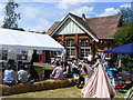
Village Hall, Fornham All Saints
Seen here during the annual Scarecrow Festival fundrasing weekend of activities.
Image: © Stuart Shepherd
Taken: 15 Jun 2009
0.02 miles
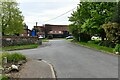
2
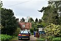
Fornham All Saints: House in Forge End
Image: © Michael Garlick
Taken: 13 May 2021
0.03 miles
3
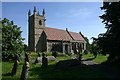
Fornham All Saints Church
Just north of Bury St Edmunds, this church is much older than it looks.
Image: © Bob Jones
Taken: 22 Jun 2005
0.03 miles
5
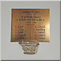
World War One memorial in Fornham All Saints church
The memorial bears ten names of those who fell in the Great War but the other memorial bears twelve names.
It may be that Pte. W. Harvey and S/Sgt. E. L. Mackmurdo didn't attend the church, as it wasn't unknown for the incumbent to only include those who attended his church on a church memorial.
Image: © Adrian S Pye
Taken: 10 Jan 2017
0.05 miles
7
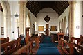
All Saints, Fornham All Saints - West end
Image: © John Salmon
Taken: 1 Aug 2012
0.06 miles
8
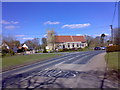
The church, Fornham All Saints
Lying on a turn in The Green, the main road of the village.
Image: © Carl Grove
Taken: 13 Apr 2013
0.06 miles
9
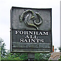
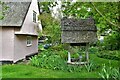
Fornham All Saints village sign (reverse)
A dark unpainted sign depicting crossed swords and a steel helmet commemorating two battles which took place here. In around 902 King Edward fought off a cousin to retain the English crown and in 1173 Henry II defeated the Earl of Leicester and a Flemish army at the Battle of Fornham. The fish on the reverse are trout and are there because the word Fornham means 'trout village' derived from the old English words forne and ham. https://www.geograph.org.uk/photo/4292707
Image: © Adrian S Pye
Taken: 19 Dec 2020
0.06 miles
10
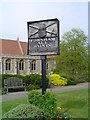
Fornham All Saints village sign
A dark unpainted sign depicting crossed swords and a steel helmet commemorating two battles which took place here. In around 902 King Edward fought off a cousin to retain the English crown and in 1173 Henry II defeated the Earl of Leicester and a Flemish army at the Battle of Fornham. The fish on the reverse are trout and are there because the word Fornham means 'trout village' derived from the old English words forne and ham.
https://www.geograph.org.uk/photo/6753472
Image: © Adrian S Pye
Taken: 25 Aug 2008
0.06 miles