IMAGES TAKEN NEAR TO
West Stow, BURY ST. EDMUNDS, IP28 6HF
Introduction
This page details the photographs taken nearby to IP28 6HF by members of the Geograph project.
The Geograph project started in 2005 with the aim of publishing, organising and preserving representative images for every square kilometre of Great Britain, Ireland and the Isle of Man.

There are currently over 7.5m images from over14,400 individuals and you can help contribute to the project by visiting https://www.geograph.org.uk
Image Map
Images are licensed for reuse under creativecommons.org/licenses/by-sa/2.0
Notes
- Clicking on the map will re-center to the selected point.
- The higher the marker number, the further away the image location is from the centre of the postcode.
Image Listing (5 Images Found)
Images are licensed for reuse under creativecommons.org/licenses/by-sa/2.0
Image
Details
Distance
1
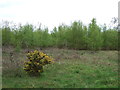
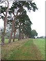
Field margin at Icklingham
The wooded area is the southern fringe of The King's Forest.
Image: © Bob Jones
Taken: 22 Jul 2006
0.10 miles
2
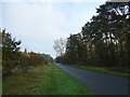
Footpath Junction
Footpath of the long distance path The Icknield Way near to Lackford, Suffolk.
Image: © Keith Evans
Taken: 10 Nov 2011
0.15 miles
3
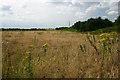
Belt Of Trees
Belt of trees near to Lackford, Suffolk.
Image: © Keith Evans
Taken: 10 Nov 2011
0.17 miles