IMAGES TAKEN NEAR TO
Crooked Chimney Row, BURY ST. EDMUNDS, IP28 6HB
Introduction
This page details the photographs taken nearby to Crooked Chimney Row, IP28 6HB by members of the Geograph project.
The Geograph project started in 2005 with the aim of publishing, organising and preserving representative images for every square kilometre of Great Britain, Ireland and the Isle of Man.

There are currently over 7.5m images from over14,400 individuals and you can help contribute to the project by visiting https://www.geograph.org.uk
Image Map
Images are licensed for reuse under creativecommons.org/licenses/by-sa/2.0
Notes
- Clicking on the map will re-center to the selected point.
- The higher the marker number, the further away the image location is from the centre of the postcode.
Image Listing (32 Images Found)
Images are licensed for reuse under creativecommons.org/licenses/by-sa/2.0
Image
Details
Distance
1
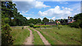
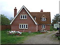
Track off Icklingham Road, West Stow
Sewage works to left of picture
Image: © Richard Cooke
Taken: 5 Aug 2011
0.03 miles
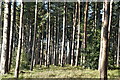
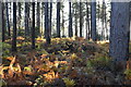
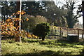
2
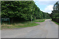
Kings Forest, West Stow
Access to a car park at Forest Lodge.
Image: © Hugh Venables
Taken: 26 Jun 2021
0.07 miles
6
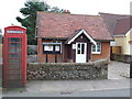
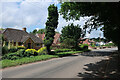
Phonebox and Clubhouse
Village phonebox outside West Stow and Wordwell Club, West Stow Suffolk.
Image: © Keith Evans
Taken: 6 Aug 2008
0.14 miles
10
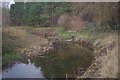
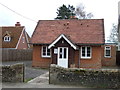
River Lark, near West Stow
Looking around a bend in the river from the Lark Valley Path.
Image: © Stephen McKay
Taken: 26 Dec 2011
0.15 miles