IMAGES TAKEN NEAR TO
West Stow, BURY ST. EDMUNDS, IP28 6ER
Introduction
This page details the photographs taken nearby to IP28 6ER by members of the Geograph project.
The Geograph project started in 2005 with the aim of publishing, organising and preserving representative images for every square kilometre of Great Britain, Ireland and the Isle of Man.

There are currently over 7.5m images from over14,400 individuals and you can help contribute to the project by visiting https://www.geograph.org.uk
Image Map
Images are licensed for reuse under creativecommons.org/licenses/by-sa/2.0
Notes
- Clicking on the map will re-center to the selected point.
- The higher the marker number, the further away the image location is from the centre of the postcode.
Image Listing (14 Images Found)
Images are licensed for reuse under creativecommons.org/licenses/by-sa/2.0
Image
Details
Distance
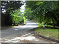
6
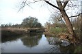
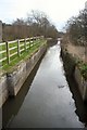
Approach to Chimney Mill Lock
This section of the former River Lark Navigation is canalised. The lock itself is disused.
Image: © Bob Jones
Taken: 24 Jan 2008
0.20 miles
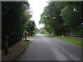
9
Chimney Mill Lock
This disused lock on the former River Lark Navigation was repaired in the 1940s, but has not been used since then.
Image: © Bob Jones
Taken: 24 Jan 2008
0.21 miles
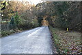
10
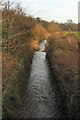
Flempton Lock, River Lark
Disused for over 100 years, this is one of 15 former locks on the river between Mildenhall and Bury St Edmunds.
Image: © Bob Jones
Taken: 24 Dec 2007
0.22 miles