IMAGES TAKEN NEAR TO
Chestnut Close, BURY ST. EDMUNDS, IP28 6AF
Introduction
This page details the photographs taken nearby to Chestnut Close, IP28 6AF by members of the Geograph project.
The Geograph project started in 2005 with the aim of publishing, organising and preserving representative images for every square kilometre of Great Britain, Ireland and the Isle of Man.

There are currently over 7.5m images from over14,400 individuals and you can help contribute to the project by visiting https://www.geograph.org.uk
Image Map
Images are licensed for reuse under creativecommons.org/licenses/by-sa/2.0
Notes
- Clicking on the map will re-center to the selected point.
- The higher the marker number, the further away the image location is from the centre of the postcode.
Image Listing (46 Images Found)
Images are licensed for reuse under creativecommons.org/licenses/by-sa/2.0
Image
Details
Distance
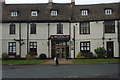
1
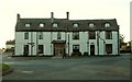
'The Olde Bull Inn' at Barton Mills
This old 16th century coaching inn stands along part of the original A.11
Image: © Robert Edwards
Taken: 9 Nov 2007
0.02 miles
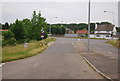
3
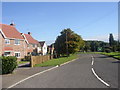
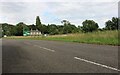
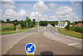
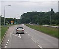
Barton Mills
These nice houses are beside the A11 just as it reaches the Barton Mills roundabout junction (sign is visible)
Image: © mike
Taken: 6 Oct 2005
0.04 miles
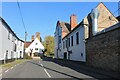
7
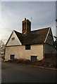
Old house at Barton Mills
The plaque at the foot of the chimney indicates the date of the house's construction - 1668.
Image: © Bob Jones
Taken: 26 Dec 2007
0.06 miles