IMAGES TAKEN NEAR TO
RAF Lakenheath, BRANDON, IP27 9PS
Introduction
This page details the photographs taken nearby to IP27 9PS by members of the Geograph project.
The Geograph project started in 2005 with the aim of publishing, organising and preserving representative images for every square kilometre of Great Britain, Ireland and the Isle of Man.

There are currently over 7.5m images from over14,400 individuals and you can help contribute to the project by visiting https://www.geograph.org.uk
Image Map
Images are licensed for reuse under creativecommons.org/licenses/by-sa/2.0
Notes
- Clicking on the map will re-center to the selected point.
- The higher the marker number, the further away the image location is from the centre of the postcode.
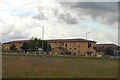
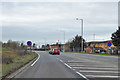
Image Listing (4 Images Found)
Images are licensed for reuse under creativecommons.org/licenses/by-sa/2.0
Image
Details
Distance
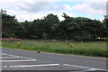
1
Entrance to RAF Lakenheath
Looking across the A1065 from a bridleway towards the No. 1 Gate to the US Air Force base at RAF Lakenheath.
Image: © Bob Jones
Taken: 28 Jun 2007
0.02 miles
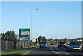
3
A1065 Brandon Road heading south
At the entrance to Lakenheath air base.
Image: © Robin Webster
Taken: 7 Mar 2020
0.03 miles