IMAGES TAKEN NEAR TO
Arrowhead Drive, BRANDON, IP27 9JN
Introduction
This page details the photographs taken nearby to Arrowhead Drive, IP27 9JN by members of the Geograph project.
The Geograph project started in 2005 with the aim of publishing, organising and preserving representative images for every square kilometre of Great Britain, Ireland and the Isle of Man.

There are currently over 7.5m images from over14,400 individuals and you can help contribute to the project by visiting https://www.geograph.org.uk
Image Map
Images are licensed for reuse under creativecommons.org/licenses/by-sa/2.0
Notes
- Clicking on the map will re-center to the selected point.
- The higher the marker number, the further away the image location is from the centre of the postcode.
Image Listing (17 Images Found)
Images are licensed for reuse under creativecommons.org/licenses/by-sa/2.0
Image
Details
Distance
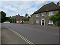
1
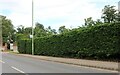
Station Road, Lakenheath
Lakenheath Hall Park is being constructed behind the hedge
Image: © David Howard
Taken: 6 Jul 2021
0.15 miles
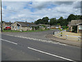
5
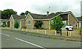
Hallfields, Lakenheath
New houses on the edge of the village.
Image: © Mary and Angus Hogg
Taken: 31 Aug 2021
0.18 miles
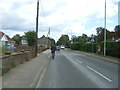
9
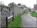
Dumpling Bridge Lane
Dumpling Bridge Lane at Lakenheath, Suffolk this would have gone through to Dumpling Bridge before the cut off channel was constructed in the 1950/60s.
Image: © Keith Evans
Taken: 18 Nov 2015
0.20 miles
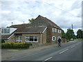
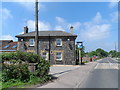
10
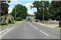
B1112 High Street, Lakenheath
North of the centre.
Image: © Robin Webster
Taken: 12 Jul 2020
0.21 miles