IMAGES TAKEN NEAR TO
Undley Road, BRANDON, IP27 9BX
Introduction
This page details the photographs taken nearby to Undley Road, IP27 9BX by members of the Geograph project.
The Geograph project started in 2005 with the aim of publishing, organising and preserving representative images for every square kilometre of Great Britain, Ireland and the Isle of Man.

There are currently over 7.5m images from over14,400 individuals and you can help contribute to the project by visiting https://www.geograph.org.uk
Image Map
Images are licensed for reuse under creativecommons.org/licenses/by-sa/2.0
Notes
- Clicking on the map will re-center to the selected point.
- The higher the marker number, the further away the image location is from the centre of the postcode.
Image Listing (7 Images Found)
Images are licensed for reuse under creativecommons.org/licenses/by-sa/2.0
Image
Details
Distance
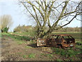
1
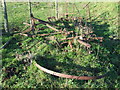
Old Farm Machinery
The remains of an old piece of farm machinery near to Lakenheath; for close up of the maker's name see http://www.geograph.org.uk/photo/4752513
Image: © Keith Evans
Taken: 25 Nov 2015
0.08 miles
2
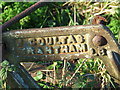
Maker Name
Maker name on the remains of a piece of old farm machinery; for overall view see http://www.geograph.org.uk/photo/4752508;
Image: © Keith Evans
Taken: 25 Nov 2015
0.08 miles
3
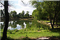
Former clay pit at Undley
This flooded pit is now used by the Lakenheath Angling Club. The foreground and part of the water is within the grid square.
Image: © Bob Jones
Taken: 15 Aug 2008
0.13 miles
4
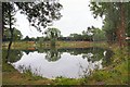
Former claypit at Undley
This former claypit is now a well-stocked pond used by the Lakenheath Angling Club.
Image: © Bob Jones
Taken: 11 Jun 2007
0.15 miles
5
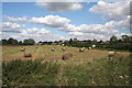
Harvested field near Lakenheath
This field is situated to the west of the village of Lakenheath, viewed from the Undley Road.
Image: © Bob Jones
Taken: 15 Aug 2008
0.20 miles
6
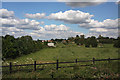
Paddocks near Lakenheath
These fields lie to the west of the village of Lakenheath.
Image: © Bob Jones
Taken: 15 Aug 2008
0.22 miles
7
Burnt Out Car
Burnt out car near to Lakenheath, Suffolk.
Image: © Keith Evans
Taken: 18 Nov 2015
0.24 miles