IMAGES TAKEN NEAR TO
Eriswell, BRANDON, IP27 9BS
Introduction
This page details the photographs taken nearby to IP27 9BS by members of the Geograph project.
The Geograph project started in 2005 with the aim of publishing, organising and preserving representative images for every square kilometre of Great Britain, Ireland and the Isle of Man.

There are currently over 7.5m images from over14,400 individuals and you can help contribute to the project by visiting https://www.geograph.org.uk
Image Map
Images are licensed for reuse under creativecommons.org/licenses/by-sa/2.0
Notes
- Clicking on the map will re-center to the selected point.
- The higher the marker number, the further away the image location is from the centre of the postcode.
Image Listing (5 Images Found)
Images are licensed for reuse under creativecommons.org/licenses/by-sa/2.0
Image
Details
Distance

2
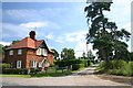
Track to High Lodge
This private track leads eastwards from the A1065 to High Lodge on the Elveden Estate.
Image: © Bob Jones
Taken: 28 Jun 2007
0.01 miles

5
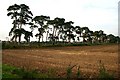
Elveden Estate trees
Several fields are divided by lines of trees running north-south.
Image: © Bob Jones
Taken: 11 Oct 2007
0.15 miles