IMAGES TAKEN NEAR TO
The Street, BRANDON, IP27 9BH
Introduction
This page details the photographs taken nearby to The Street, IP27 9BH by members of the Geograph project.
The Geograph project started in 2005 with the aim of publishing, organising and preserving representative images for every square kilometre of Great Britain, Ireland and the Isle of Man.

There are currently over 7.5m images from over14,400 individuals and you can help contribute to the project by visiting https://www.geograph.org.uk
Image Map
Images are licensed for reuse under creativecommons.org/licenses/by-sa/2.0
Notes
- Clicking on the map will re-center to the selected point.
- The higher the marker number, the further away the image location is from the centre of the postcode.
Image Listing (14 Images Found)
Images are licensed for reuse under creativecommons.org/licenses/by-sa/2.0
Image
Details
Distance
1
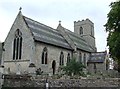
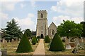
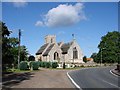
St Lawrence Eriswell
The village church of St Lawrence Eriswell, Suffolk; for info on the church see http://www.suffolkchurches.co.uk/eriswell.htm
Image: © Keith Evans
Taken: 3 Oct 2013
0.03 miles
2
Grave Stone
Grave stone to an North American Indian in the churchyard of St Lawrence Eriswell, Suffolk.
Image: © Keith Evans
Taken: 3 Oct 2013
0.03 miles
3
Church of St Laurence and St Peter, Eriswell
Image: © David Howard
Taken: 6 Jul 2021
0.03 miles
4
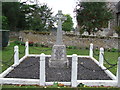
Eriswell War Memorial
The war memorial at Eriswell, Suffolk; for roll of honour see Image
Image: © Keith Evans
Taken: 3 Oct 2013
0.03 miles
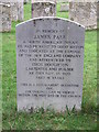
5
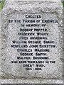
Roll Of Honour
The roll of honour on the war memorial at Eriswell, Suffolk; for overall view see https://www.geograph.org.uk/photo/3689028
Image: © Keith Evans
Taken: 3 Oct 2013
0.03 miles
6
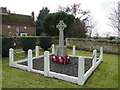
Eriswell War Memorial
The memorial stands close to the church and bears the names of seven men who went to war and never returned and another who is buried in the churchyard, who died from his wounds at home.
Another memorial plaque for Eriswell is featured on the Elveden memorial and can be seen here > https://www.geograph.org.uk/photo/6571977
Image: © Adrian S Pye
Taken: 6 Feb 2017
0.03 miles
7
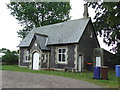
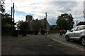
Reading Rooms
Old reading rooms at Eriswell, Suffolk.
Image: © Keith Evans
Taken: 3 Oct 2013
0.05 miles
8
Eriswell Church
Unusual cone-shaped yews line the churchyard at the rear of St Lawrence Church.
Image: © Bob Jones
Taken: 25 Jul 2006
0.06 miles
9
Eriswell St Peter and All Saints church
Originally dedicated to St. Laurence as a Chapel of Ease The dedication proved unpopular and is not as commonly used as St Peter, which was transferred from the original church. > http://www.geograph.org.uk/photo/2088588 An interesting building and much of it is 14th & 15th century workmanship. Entry is gained from the north porch and the 14th century font is immediately noticeable with clustered columns forming the central shaft. The south aisle is almost as large as the main aisle and contains all the usual accoutrements, including a piscina, complete with credence shelf, and an aumbry. There is an earlier 14th century piscina in the chancel and the sedilia with arm rests. There are some old benches, the carvings on which have been dreadfully mutilated.
Image: © Adrian S Pye
Taken: 28 Jul 2007
0.06 miles
10
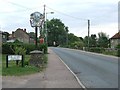
Village Sign
Village sign at Eriswell, Suffolk; for close up view see http://www.geograph.org.uk/photo/3689019
Image: © Keith Evans
Taken: 3 Oct 2013
0.10 miles