IMAGES TAKEN NEAR TO
Little Eriswell, BRANDON, IP27 9AZ
Introduction
This page details the photographs taken nearby to IP27 9AZ by members of the Geograph project.
The Geograph project started in 2005 with the aim of publishing, organising and preserving representative images for every square kilometre of Great Britain, Ireland and the Isle of Man.

There are currently over 7.5m images from over14,400 individuals and you can help contribute to the project by visiting https://www.geograph.org.uk
Image Map
Images are licensed for reuse under creativecommons.org/licenses/by-sa/2.0
Notes
- Clicking on the map will re-center to the selected point.
- The higher the marker number, the further away the image location is from the centre of the postcode.
Image Listing (7 Images Found)
Images are licensed for reuse under creativecommons.org/licenses/by-sa/2.0
Image
Details
Distance
1

Common Lane
Bridleway to the Cut-off Channel.
Image: © Hugh Venables
Taken: 5 May 2012
0.14 miles
2

B1112 past Lakenheath Airfield
The road to the right is marked on the map as seemingly public, but it isn't.
Image: © Hugh Venables
Taken: 5 May 2012
0.15 miles
3

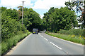
B1112 to Lakenheath
Between Lakenheath Airfield and Lakenheath village.
Image: © Hugh Venables
Taken: 5 May 2012
0.17 miles
5
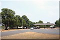
RAF Lakenheath Gate No. 2
The 'rear' entrance to the United States Air Force base.
Image: © Bob Jones
Taken: 25 Jul 2006
0.17 miles
6
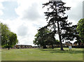
The edge of the vast married quarters at USAF Lakenheath
Image: © Adrian S Pye
Taken: 26 May 2015
0.19 miles
7

Common Lane
Bridleway to the Cut-off Channel, through some damp woodland.
Image: © Hugh Venables
Taken: 5 May 2012
0.23 miles