IMAGES TAKEN NEAR TO
Kestrel Drive, BRANDON, IP27 0UA
Introduction
This page details the photographs taken nearby to Kestrel Drive, IP27 0UA by members of the Geograph project.
The Geograph project started in 2005 with the aim of publishing, organising and preserving representative images for every square kilometre of Great Britain, Ireland and the Isle of Man.

There are currently over 7.5m images from over14,400 individuals and you can help contribute to the project by visiting https://www.geograph.org.uk
Image Map
Images are licensed for reuse under creativecommons.org/licenses/by-sa/2.0
Notes
- Clicking on the map will re-center to the selected point.
- The higher the marker number, the further away the image location is from the centre of the postcode.
Image Listing (10 Images Found)
Images are licensed for reuse under creativecommons.org/licenses/by-sa/2.0
Image
Details
Distance
1
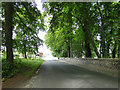
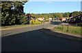
Thetford Road, Brandon meeting the A1107
Image: © Adrian S Pye
Taken: 26 May 2015
0.10 miles
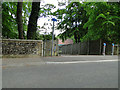
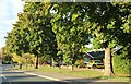
2
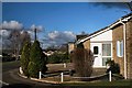
Brandon housing estate
Modern bungalows on the eastern fringe of Brandon.
Image: © Bob Jones
Taken: 24 Jan 2007
0.10 miles
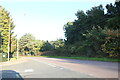
3
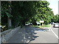
Thetford Road
Minor road off the B1107 heading east towards Santon Downham.
Image: © JThomas
Taken: 16 Jul 2015
0.11 miles
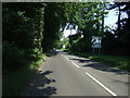
6
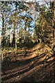
Footpath to Brandon
This path leads from Santon Downham to Brandon.
Image: © Bob Jones
Taken: 24 Jan 2007
0.14 miles
8
B1107 Thetford Road, Brandon
Towards the town centre.
Image: © Robin Webster
Taken: 7 Mar 2020
0.16 miles
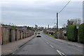
10
Green Road at the junction of Blackbird Avenue
Image: © David Howard
Taken: 2 Oct 2022
0.19 miles