IMAGES TAKEN NEAR TO
Santon Downham, BRANDON, IP27 0TX
Introduction
This page details the photographs taken nearby to IP27 0TX by members of the Geograph project.
The Geograph project started in 2005 with the aim of publishing, organising and preserving representative images for every square kilometre of Great Britain, Ireland and the Isle of Man.

There are currently over 7.5m images from over14,400 individuals and you can help contribute to the project by visiting https://www.geograph.org.uk
Image Map
Images are licensed for reuse under creativecommons.org/licenses/by-sa/2.0
Notes
- Clicking on the map will re-center to the selected point.
- The higher the marker number, the further away the image location is from the centre of the postcode.
Image Listing (19 Images Found)
Images are licensed for reuse under creativecommons.org/licenses/by-sa/2.0
Image
Details
Distance
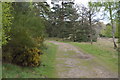
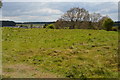
1
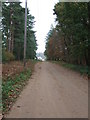
To Little Lodge Farm
Track leading to Little Lodge Farm near to Santon Downham, Suffolk.
Image: © Keith Evans
Taken: 18 Nov 2010
0.02 miles
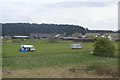
5
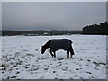
Snowy horse fields
At Little Lodge Farm. For more details of the farm, see http://www.littlelodgefarm.co.uk/ One hyperactive horse didn't have a coat on, either because it kept itself warm chasing all the others, or because no-one could catch it.
Image: © Hugh Venables
Taken: 22 Dec 2009
0.15 miles
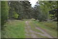
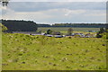
10
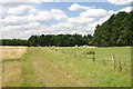
Footpath to Santon Downham
The Little Ouse Path heads westwards at this point, past Little Lodge Farm.
Image: © Bob Jones
Taken: 6 Aug 2007
0.21 miles