IMAGES TAKEN NEAR TO
BRANDON, IP27 0ST
Introduction
This page details the photographs taken nearby to IP27 0ST by members of the Geograph project.
The Geograph project started in 2005 with the aim of publishing, organising and preserving representative images for every square kilometre of Great Britain, Ireland and the Isle of Man.

There are currently over 7.5m images from over14,400 individuals and you can help contribute to the project by visiting https://www.geograph.org.uk
Image Map
Images are licensed for reuse under creativecommons.org/licenses/by-sa/2.0
Notes
- Clicking on the map will re-center to the selected point.
- The higher the marker number, the further away the image location is from the centre of the postcode.
Image Listing (8 Images Found)
Images are licensed for reuse under creativecommons.org/licenses/by-sa/2.0
Image
Details
Distance
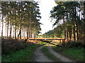
1
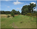
Path near Mayday Farm
The edge of the open access area.
Image: © Hugh Venables
Taken: 24 Mar 2017
0.10 miles
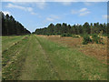
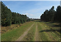
3
Forest track
A track through Thetford Forest.
Image: © Peter Mackenzie
Taken: 3 May 2017
0.17 miles
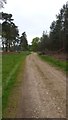
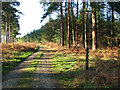
4
Very Wide Forest Track
Wide forest track looking north west near to Eleveden, Suffolk.
Image: © Keith Evans
Taken: 11 Apr 2017
0.21 miles
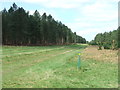
8
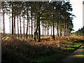
Trees on the edge of Upper Elvedon Warren
Image: © Evelyn Simak
Taken: 9 Dec 2011
0.24 miles