IMAGES TAKEN NEAR TO
Colveston, THETFORD, IP26 5HU
Introduction
This page details the photographs taken nearby to IP26 5HU by members of the Geograph project.
The Geograph project started in 2005 with the aim of publishing, organising and preserving representative images for every square kilometre of Great Britain, Ireland and the Isle of Man.

There are currently over 7.5m images from over14,400 individuals and you can help contribute to the project by visiting https://www.geograph.org.uk
Image Map
Images are licensed for reuse under creativecommons.org/licenses/by-sa/2.0
Notes
- Clicking on the map will re-center to the selected point.
- The higher the marker number, the further away the image location is from the centre of the postcode.
Image Listing (4 Images Found)
Images are licensed for reuse under creativecommons.org/licenses/by-sa/2.0
Image
Details
Distance
1
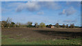
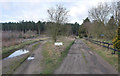
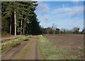
Panorama of field with house in background
Image: © David Pashley
Taken: 7 Mar 2019
0.10 miles
3
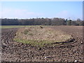
Remains of Colveston Church
All that remains of the church of Colveston St Mary the Virgin. Deserted and demolished in the 18th c. Only few walls remain just above ground level. The area of the church remains un-ploughed in the middle of a field. Private Land. Photograph taken with express permission of the landowner.
Image: © Adrian S Pye
Taken: 19 Feb 2010
0.21 miles