1
St Leonards Street, Mundford
Image: © Hugh Venables
Taken: 2 Oct 2018
0.02 miles
2
St Leonards Street, Mundford
A miserably wet New Year's Day morning in this Norfolk village.
Image: © Stephen McKay
Taken: 1 Jan 2017
0.02 miles
3
Mundford Store
Costcutter convenience store and a post office
Image: © Hugh Venables
Taken: 2 Oct 2018
0.04 miles
4
View from the Crown inn at Mundford
The Crown overlooks the small formal triangular village green. Sitting by this window you have no excuse for forgetting the name of the pub.
Image: © Chris Brown
Taken: 2 Nov 2017
0.05 miles
5
The green at Mundford
Looking into St Leonard's Street.
Image: © Chris Brown
Taken: 2 Nov 2017
0.06 miles
6
West side of the green at Mundford
Looking across from the Crown.
Image: © Chris Brown
Taken: 2 Nov 2017
0.06 miles
7
Mundford village sign
The sign is double sided, north and south facing. The north face shows St Leonard’s church from the east and a woolly mammoth, remains of which were found in Lynford quarry. The River Wissey has fish swimming therein. A stag represents the surrounding countryside and the crown and date 1650 represent the Crown Hotel in the village. The birds are stone curlews which are also known as the Norfolk plover inhabit the Brecks. The frame is decorated with local fauna.
On the south face, St Leonard’s church, as viewed from the south with fir cones, a squirrel and a stag representing the surrounding countryside. Below is a thatched manor house one of two recorded manors anciently Montfort Manor, named after that family and below that is the Crown Hotel. https://www.geograph.org.uk/photo/6791116 https://www.geograph.org.uk/photo/6791122
Image: © Adrian S Pye
Taken: 29 Mar 2021
0.07 miles
8
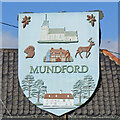
Mundford village sign (south face)
The sign is double sided, north and south facing. On the south face, St Leonard’s church, as viewed from the south with fir cones, a squirrel and a stag representing the surrounding countryside. Below is a thatched manor house one of two recorded manors anciently Montfort Manor, named after that family and below that is the Crown Hotel.
The north face shows St Leonard’s church from the east and a woolly mammoth, remains of which were found in Lynford quarry. The River Wissey has fish swimming therein. A stag represents the surrounding countryside and the crown and date 1650 represent the Crown Hotel in the village. The birds are stone curlews which are also known as the Norfolk plover inhabit the Brecks. The frame is decorated with local fauna. https://www.geograph.org.uk/photo/6791116 https://www.geograph.org.uk/photo/6791127
Image: © Adrian S Pye
Taken: 29 Mar 2021
0.07 miles
9
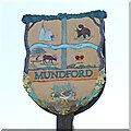
Mundford village sign (north face)
The sign is double sided, north and south facing. The north face shows St Leonard’s church from the east and a woolly mammoth, remains of which were found in Lynford quarry. The River Wissey has fish swimming therein. A stag represents the surrounding countryside and the crown and date 1650 represent the Crown Hotel in the village. The birds are stone curlews which are also known as the Norfolk plover inhabit the Brecks. The frame is decorated with local fauna.
On the south face, St Leonard’s church, as viewed from the south with fir cones, a squirrel and a stag representing the surrounding countryside. Below is a thatched manor house one of two recorded manors anciently Montfort Manor, named after that family and below that is the Crown Hotel. https://www.geograph.org.uk/photo/6791122 https://www.geograph.org.uk/photo/6791127
Image: © Adrian S Pye
Taken: 29 Mar 2021
0.07 miles
10
Looking south at Mundford green
Flint, red and yellow brick, pantiles and a village sign.
Image: © Chris Brown
Taken: 2 Nov 2017
0.07 miles


