IMAGES TAKEN NEAR TO
Brandon Road, THETFORD, IP26 5EU
Introduction
This page details the photographs taken nearby to Brandon Road, IP26 5EU by members of the Geograph project.
The Geograph project started in 2005 with the aim of publishing, organising and preserving representative images for every square kilometre of Great Britain, Ireland and the Isle of Man.

There are currently over 7.5m images from over14,400 individuals and you can help contribute to the project by visiting https://www.geograph.org.uk
Image Map
Images are licensed for reuse under creativecommons.org/licenses/by-sa/2.0
Notes
- Clicking on the map will re-center to the selected point.
- The higher the marker number, the further away the image location is from the centre of the postcode.
Image Listing (6 Images Found)
Images are licensed for reuse under creativecommons.org/licenses/by-sa/2.0
Image
Details
Distance
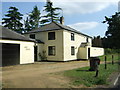
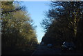
2
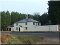
Covert Cottage
Marked on the 1:25:000 Ordnance Survey as Covert Cottage it stands at the side of the A1065 between Brandon and Mundford.
Image: © Keith Evans
Taken: 4 Jan 2007
0.19 miles
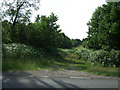
6
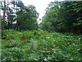
Overgrown Forest Track
Marked on the O.S. 1:25:000 as a forest track it now appears to be a bit overgrown near to Mundford Norfolk.
Image: © Keith Evans
Taken: 29 Jul 2007
0.25 miles