IMAGES TAKEN NEAR TO
Lynford, THETFORD, IP26 5ET
Introduction
This page details the photographs taken nearby to IP26 5ET by members of the Geograph project.
The Geograph project started in 2005 with the aim of publishing, organising and preserving representative images for every square kilometre of Great Britain, Ireland and the Isle of Man.

There are currently over 7.5m images from over14,400 individuals and you can help contribute to the project by visiting https://www.geograph.org.uk
Image Map
Images are licensed for reuse under creativecommons.org/licenses/by-sa/2.0
Notes
- Clicking on the map will re-center to the selected point.
- The higher the marker number, the further away the image location is from the centre of the postcode.
Image Listing (22 Images Found)
Images are licensed for reuse under creativecommons.org/licenses/by-sa/2.0
Image
Details
Distance
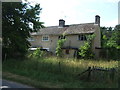
1
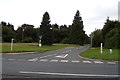
Brandon Road, Lyndford
At the junction with the A134 Mundford Road & West Tofts Road
Image: © Geographer
Taken: 21 Sep 2017
0.02 miles
2
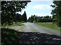
Lynford Crossroads
Looking at the crossroads Lynford, Norfolk.
Image: © Keith Evans
Taken: 23 Aug 2009
0.03 miles
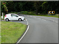
3
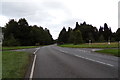
A134 Mundford Road, Lynford
At the junction with West Tofts Road & Brandon Road
Image: © Geographer
Taken: 21 Sep 2017
0.03 miles
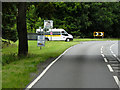
5
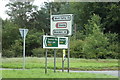
Roadsigns on the A134 Mundford Road
At the junction with West Tofts Road & Brandon Road
Image: © Geographer
Taken: 21 Sep 2017
0.03 miles
6
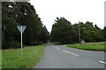
West Tofts Road, Lyndford
At the junction with the A134 Mundford Road & Brandon Road
Image: © Geographer
Taken: 21 Sep 2017
0.03 miles
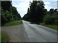
10

A134 at the Grime's Graves turnoff to the left
Image: © Adrian S Pye
Taken: 17 Feb 2015
0.11 miles