IMAGES TAKEN NEAR TO
Southburgh Road, THETFORD, IP25 7SG
Introduction
This page details the photographs taken nearby to Southburgh Road, IP25 7SG by members of the Geograph project.
The Geograph project started in 2005 with the aim of publishing, organising and preserving representative images for every square kilometre of Great Britain, Ireland and the Isle of Man.

There are currently over 7.5m images from over14,400 individuals and you can help contribute to the project by visiting https://www.geograph.org.uk
Image Map
Images are licensed for reuse under creativecommons.org/licenses/by-sa/2.0
Notes
- Clicking on the map will re-center to the selected point.
- The higher the marker number, the further away the image location is from the centre of the postcode.
Image Listing (31 Images Found)
Images are licensed for reuse under creativecommons.org/licenses/by-sa/2.0
Image
Details
Distance
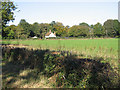
1
Heading south east from Cranworth
Towards Woodrising.
Image: © JThomas
Taken: 17 Jun 2017
0.07 miles
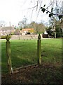
3
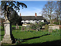
Church Farm
Viewed from the churchyard of > Image The monument featuring an angel with a trumpet (seen at left) is the war memorial.
Image: © Evelyn Simak
Taken: 25 Feb 2008
0.12 miles
4
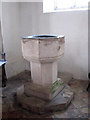
St Mary's church - baptismal font
14th century baptismal font.
The main features of St Mary's church date from the 14th century; the tower has a parapet and, unusual for Norfolk, a recessed spire. The lead roof is from 1919. The church furniture is elaborately carved from oak, the communion rail has a design of mouchette wheels. The church contains a number of interesting wall monuments, most of these to the Gurdons who lived at Letton Hall. The church is kept locked but a key is readily available. For more information see: http://www.norfolkchurches.co.uk/cranworth/cranworth.htm
Image: © Evelyn Simak
Taken: 25 Feb 2008
0.13 miles
5
Cranworth - the stocks on the church green
Stocks made from wood or iron were used from Anglo-Saxon times until 1837 for punishing minor offences such as drunkenness, resisting a constable or drinking alcohol during a church service. The offender had to sit with ankles locked in place for a specified time, as decreed by the magistrate. The hands were free so defence from the crowd was possible. According to a law passed in 1405 every town and village had to have a set of stocks. These were usually placed beside a public highway or at a village green. http://www.villagenet.co.uk/reference/stocks.html
Image: © Evelyn Simak
Taken: 25 Feb 2008
0.13 miles
6
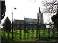
St Mary's church
Viewed through the iron churchyard gates.
The main features of St Mary's church date from the 14th century; the tower has a parapet and, unusual for Norfolk, a recessed spire. The lead roof is from 1919. The church furniture is elaborately carved from oak > Image, the communion rail has a design of mouchette wheels > Image The church contains a number of interesting wall monuments > Image - Image - Image, most of these to the Gurdons who lived at Letton Hall. The church is kept locked but a key is readily available. For more information see: http://www.norfolkchurches.co.uk/cranworth/cranworth.htm
Image: © Evelyn Simak
Taken: 25 Feb 2008
0.13 miles
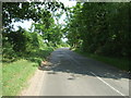
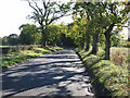
7
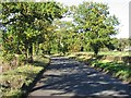
The Road To Cranworth
From Woodrising.
Image: © Roger Gilbertson
Taken: 3 Nov 2006
0.14 miles
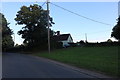
8
A Country Cottage
Between Cranworth and Woodrising.
Image: © Roger Gilbertson
Taken: 3 Nov 2006
0.14 miles
9
The Road To Scoulton
From Woodrising.
Image: © Roger Gilbertson
Taken: 3 Nov 2006
0.14 miles