IMAGES TAKEN NEAR TO
King Row, THETFORD, IP25 7RN
Introduction
This page details the photographs taken nearby to King Row, IP25 7RN by members of the Geograph project.
The Geograph project started in 2005 with the aim of publishing, organising and preserving representative images for every square kilometre of Great Britain, Ireland and the Isle of Man.

There are currently over 7.5m images from over14,400 individuals and you can help contribute to the project by visiting https://www.geograph.org.uk
Image Map
Images are licensed for reuse under creativecommons.org/licenses/by-sa/2.0
Notes
- Clicking on the map will re-center to the selected point.
- The higher the marker number, the further away the image location is from the centre of the postcode.
Image Listing (21 Images Found)
Images are licensed for reuse under creativecommons.org/licenses/by-sa/2.0
Image
Details
Distance
4
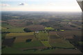
Looking southwestwards from Shipdham: aerial 2015
Between King Row and Corner Farm, with Kingrow Wood left of centre.
Image: © Chris
Taken: 19 Sep 2015
0.09 miles
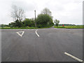
5
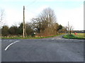
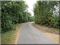
End of Long Road
This is the junction at the end of Long Road with the A1075 and King Row near to Crowshill, Norfolk.
Image: © Keith Evans
Taken: 27 Jan 2008
0.11 miles
6
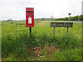
Elizabeth II post box and minor road sign
Image: © David Pashley
Taken: 18 May 2019
0.11 miles
8
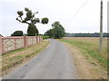
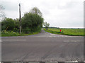
View from King Row towards Watton Dereham Road
Image: © David Pashley
Taken: 14 Aug 2020
0.12 miles
10
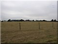
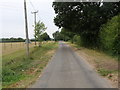
View across parched meadow from King Row
Image: © David Pashley
Taken: 14 Aug 2020
0.14 miles