IMAGES TAKEN NEAR TO
High Green Lane, THETFORD, IP25 7RE
Introduction
This page details the photographs taken nearby to High Green Lane, IP25 7RE by members of the Geograph project.
The Geograph project started in 2005 with the aim of publishing, organising and preserving representative images for every square kilometre of Great Britain, Ireland and the Isle of Man.

There are currently over 7.5m images from over14,400 individuals and you can help contribute to the project by visiting https://www.geograph.org.uk
Image Map
Images are licensed for reuse under creativecommons.org/licenses/by-sa/2.0
Notes
- Clicking on the map will re-center to the selected point.
- The higher the marker number, the further away the image location is from the centre of the postcode.
Image Listing (5 Images Found)
Images are licensed for reuse under creativecommons.org/licenses/by-sa/2.0
Image
Details
Distance
2
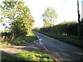
Turn Left For Route 13
A turning towards High Green on the National Cycle Network between Saham Hills and Shipdham.
Image: © Roger Gilbertson
Taken: 3 Nov 2006
0.05 miles
3
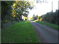
Ideal For Cyclists.
The quiet byway to East Bradenham and High Green from Saham Hills is a Sustrans route for cyclists.
Image: © Roger Gilbertson
Taken: 3 Nov 2006
0.05 miles
4
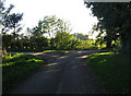
A Rural Junction
The road from High Green meets the road between Saham Hills and Shipdham.
Image: © Roger Gilbertson
Taken: 3 Nov 2006
0.05 miles
5
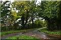
Bradenham: The High Green/ Mill Lane junction
Image: © Michael Garlick
Taken: 23 Oct 2022
0.08 miles