IMAGES TAKEN NEAR TO
Letton Road, THETFORD, IP25 7ND
Introduction
This page details the photographs taken nearby to Letton Road, IP25 7ND by members of the Geograph project.
The Geograph project started in 2005 with the aim of publishing, organising and preserving representative images for every square kilometre of Great Britain, Ireland and the Isle of Man.

There are currently over 7.5m images from over14,400 individuals and you can help contribute to the project by visiting https://www.geograph.org.uk
Image Map
Images are licensed for reuse under creativecommons.org/licenses/by-sa/2.0
Notes
- Clicking on the map will re-center to the selected point.
- The higher the marker number, the further away the image location is from the centre of the postcode.
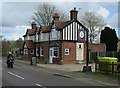
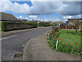
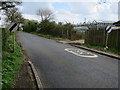
Image Listing (8 Images Found)
Images are licensed for reuse under creativecommons.org/licenses/by-sa/2.0
Image
Details
Distance
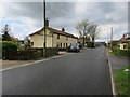
7
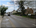
Nursery by Letton Road
Leaving Shipdham.
Image: © Hugh Venables
Taken: 17 Apr 2016
0.13 miles
8
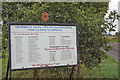
Memorial trees on the A1075 Dereham Road
The trees planted along the side of the road commemorate the men of Shipdham who were lost in both World Wars.
The names of the fallen and the sponsors both appear on this roadside information board.
Image: © Adrian S Pye
Taken: 15 Oct 2019
0.20 miles