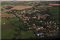
IMAGES TAKEN NEAR TO
Mill Road, THETFORD, IP25 7LU
Introduction
This page details the photographs taken nearby to Mill Road, IP25 7LU by members of the Geograph project.
The Geograph project started in 2005 with the aim of publishing, organising and preserving representative images for every square kilometre of Great Britain, Ireland and the Isle of Man.

There are currently over 7.5m images from over14,400 individuals and you can help contribute to the project by visiting https://www.geograph.org.uk
Image Map
Images are licensed for reuse under creativecommons.org/licenses/by-sa/2.0
Notes
- Clicking on the map will re-center to the selected point.
- The higher the marker number, the further away the image location is from the centre of the postcode.
Image Listing (48 Images Found)
Images are licensed for reuse under creativecommons.org/licenses/by-sa/2.0
Image
Details
Distance
2

Church Close past All Saints Church
View in easterly direction from churchyard.
Image: © Evelyn Simak
Taken: 28 Feb 2008
0.08 miles
4
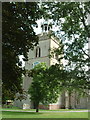
All Saints Church, Shipdham
The tower of All Saints Church, Shipdham, with an unusual little cupola on top.
Image: © Rob Farrow
Taken: 24 Jul 2003
0.09 miles
5
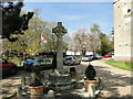
Shipdham War Memorial
The Memorial is close to the south door of Shipdham church. 29 men are names on the WW1 side of the memorial and ten on the WW2 side. There is also a reference to The Fallen of 8th Bomber Command U.S.A.A.F. which must refer to the 8th U.S Army Air Force who were based at Shipdham airfield in WW2. http://www.geograph.org.uk/article/RAF-Shipdham---USAAF-Station-115
Image: © Adrian S Pye
Taken: 5 May 2016
0.10 miles
6
Memorial to the casualties of 44 Bomb Group USAAF Shipdham
The memorial stands south of the south porch.
Image: © Adrian S Pye
Taken: 15 Oct 2019
0.10 miles
7

Shipdham Cemetery
Taken from Pound Green Lane
Image: © Andy Dowland
Taken: 20 Aug 2005
0.10 miles
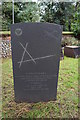
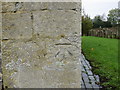
8
OS Benchmark
Recorded on Benchmark Database as 'Shipdham, All Saints Church'.
Image: © David Bremner
Taken: 8 May 2023
0.11 miles
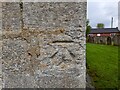
9
Ordnance Survey Cut Mark
This can be found on the wall of All Saints Church at Shipdham.
For more detail see : http://www.bench-marks.org.uk/bm62957
Image: © Peter Wood
Taken: 9 Nov 2014
0.11 miles
10
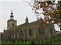
All Saints Church at Shipdham
Viewed from the south-east.
Image: © Peter Wood
Taken: 9 Nov 2014
0.11 miles