IMAGES TAKEN NEAR TO
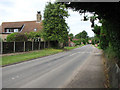
Highview Close, IP25 7FR
Introduction
This page details the photographs taken nearby to Highview Close, IP25 7FR by members of the Geograph project.
The Geograph project started in 2005 with the aim of publishing, organising and preserving representative images for every square kilometre of Great Britain, Ireland and the Isle of Man.

There are currently over 7.5m images from over14,400 individuals and you can help contribute to the project by visiting https://www.geograph.org.uk
Image Map
Images are licensed for reuse under creativecommons.org/licenses/by-sa/2.0
Notes
- Clicking on the map will re-center to the selected point.
- The higher the marker number, the further away the image location is from the centre of the postcode.
Image Listing (33 Images Found)
Images are licensed for reuse under creativecommons.org/licenses/by-sa/2.0
Image
Details
Distance
2
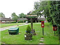
Holme Hale village sign and unassociated accoutrements
A grit bin, shrub tub, letter box and litter bin surround the village sign.
Image: © Adrian S Pye
Taken: 5 Jun 2018
0.07 miles
3
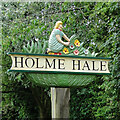
Holme Hale village sign
The sign represents the village's participation in the National Open Garden Scheme. The walled kitchen garden at The Hall, which was designed out by Arne Maynard in 2000, and replanted during 2016 and 2017 the garden can be viewed by appointment. https://www.geograph.org.uk/photo/5798591
Image: © Adrian S Pye
Taken: 5 Jun 2018
0.08 miles
4
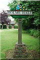
Village sign
The village sign at Holme Hale, Norfolk. A plaque reads... Original sign replaced to commemorate the Golden Jubilee 2002 funded by the Philip Robertson Bequest.
Image: © Craig Tuck
Taken: 21 Jun 2009
0.08 miles
6
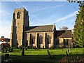
The Parish Church Of St. Andrew
Holme Hale.
Image: © Roger Gilbertson
Taken: 3 Nov 2006
0.18 miles
7
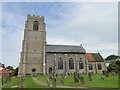
St. Andrew's church Holme Hale
The chancel roof adds a dash of colour to a grey building. This is a well proportioned 14th c. church with a substantial 15th c. tower. On the tower are bricks set into the flint as an arch, but I think these were decorative rather than there ever having been transepts of a cruciform church. The flint-work is too regular and shows no sign of disturbance. Inside the church the bench-ends are most unusual in having semi-circular cut-outs with lovely carvings. The south windows in the nave are 15th c. and they alone are worth a visit. The 15th c. font is quite plain with an octagonal bowl and shaft. A good ‘win-glass’ Stuart pulpit with steps leading up to it. In the chancel is a corner piscina; the pillar is Norman and is inverted. The sedilia is a simple dropped window-sill. A well-lit church, aided by a chancel arch window.
Image: © Adrian S Pye
Taken: 13 Jun 2010
0.19 miles
8
St Andrew, Holme Hale, Norfolk - East end
Image: © John Salmon
Taken: 29 May 2003
0.19 miles
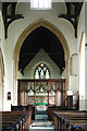
9

St Andrew's church in Holme Hale
The two villages of Holme and Hale were consolidated after the Black death had decimated the population everywhere across the country. Both village churches were dedicated to St Andrew. Hale church, the older of the two buildings, was extended whilst the church at Holme was eventually abandoned. St Andrew's church at Holme Hale as we see it today dates mainly from the 14th and 15th centuries although some parts of the structure are much older. The octagonal baptismal font > http://www.geograph.org.uk/photo/1914138 is original and dates from the 14th century. Most of the internal woodwork, including the hammerbeam nave roof, dates from the 15th century. The pews with straight-topped ends are believed to be unique in Norfolk. Each recess has a carving, one depicting an elephant > http://www.geograph.org.uk/photo/1914125 , another a squirrel, a unicorn, a bear > http://www.geograph.org.uk/photo/1914119 , wolves, birds of prey and a grinning devil > http://www.geograph.org.uk/photo/1914127. The 15th century rood screen has two intricately carved wheels > http://www.geograph.org.uk/photo/1914113 in the tracery of its door.
Image: © Evelyn Simak
Taken: 13 Jun 2010
0.20 miles
10

St Andrew's church in Holme Hale - reading desk
The two villages of Holme and Hale were consolidated after the Black death had decimated the population everywhere across the country. Both village churches were dedicated to St Andrew. Hale church, the older of the two buildings, was extended whilst the church at Holme was eventually abandoned. St Andrew's church > http://www.geograph.org.uk/photo/1914036 at Holme Hale as we see it today dates mainly from the 14th and 15th centuries although some parts of the structure are much older. The octagonal baptismal font > http://www.geograph.org.uk/photo/1914138 is original and dates from the 14th century. Most of the internal woodwork, including the hammerbeam nave roof, dates from the 15th century. The pews with straight-topped ends are believed to be unique in Norfolk. Each recess has a carving, one depicting an elephant > http://www.geograph.org.uk/photo/1914125 , another a squirrel, a unicorn, a bear > http://www.geograph.org.uk/photo/1914119 , wolves, birds of prey and a grinning devil > http://www.geograph.org.uk/photo/1914127. The 15th century rood screen has two intricately carved wheels > http://www.geograph.org.uk/photo/1914113 in the tracery of its door.
Image: © Evelyn Simak
Taken: 13 Jun 2010
0.20 miles