IMAGES TAKEN NEAR TO
Mile Road, THETFORD, IP25 7FH
Introduction
This page details the photographs taken nearby to Mile Road, IP25 7FH by members of the Geograph project.
The Geograph project started in 2005 with the aim of publishing, organising and preserving representative images for every square kilometre of Great Britain, Ireland and the Isle of Man.

There are currently over 7.5m images from over14,400 individuals and you can help contribute to the project by visiting https://www.geograph.org.uk
Image Map
Images are licensed for reuse under creativecommons.org/licenses/by-sa/2.0
Notes
- Clicking on the map will re-center to the selected point.
- The higher the marker number, the further away the image location is from the centre of the postcode.
Image Listing (17 Images Found)
Images are licensed for reuse under creativecommons.org/licenses/by-sa/2.0
Image
Details
Distance
1
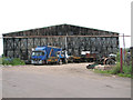
RAF hangar on Shipdham industrial estate
This is one of three T2 hangars which have survived on the industrial estate which now occupies the former Technical site of RAF Shipdham.
Image: © Evelyn Simak
Taken: 20 Jun 2014
0.06 miles
2
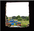
Blue skips at Shipdham industrial estate
This view was taken from the disused RAF control tower > http://www.geograph.org.uk/photo/4035688.
Image: © Evelyn Simak
Taken: 20 Jun 2014
0.11 miles
3
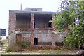
Shipdham Control Tower
Wartime Control Tower at Shipdham airfield
Image: © Richard Flagg
Taken: 15 Aug 2006
0.12 miles
4
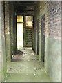
The control tower at RAF Shipdham - interior
Inside the long disused and derelict control tower of RAF Shipdham. For an exterior view see > http://www.geograph.org.uk/photo/4035688.
Image: © Evelyn Simak
Taken: 20 Jun 2014
0.12 miles
5
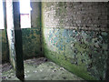
Peeling paint in the control tower
Inside the long disused and derelict control tower of RAF Shipdham. For an exterior view see > http://www.geograph.org.uk/photo/4035688.
Image: © Evelyn Simak
Taken: 20 Jun 2014
0.12 miles
6
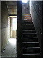
Steps leading up the control tower
Inside the long disused and derelict control tower of RAF Shipdham. For an exterior view see > http://www.geograph.org.uk/photo/4035688.
Image: © Evelyn Simak
Taken: 20 Jun 2014
0.12 miles
7
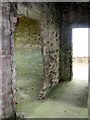
On the first floor of the control tower
Inside the long disused and derelict control tower of RAF Shipdham. For an exterior view see > http://www.geograph.org.uk/photo/4035688.
Image: © Evelyn Simak
Taken: 20 Jun 2014
0.12 miles
8
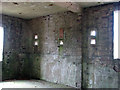
Inside the old control tower
Inside the long disused and derelict control tower of RAF Shipdham. For an exterior view see > http://www.geograph.org.uk/photo/4035688.
Image: © Evelyn Simak
Taken: 20 Jun 2014
0.12 miles
9
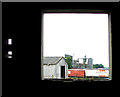
Allen & Page at Shipdham industrial estate
This view was taken through a window of the disused control tower > http://www.geograph.org.uk/photo/4035688.
Image: © Evelyn Simak
Taken: 20 Jun 2014
0.12 miles
10

44th Bomb Group memorial at Shipdham - detail
The 44th Bomb Group was known as the Flying Eightballs and this was their emblem. See also > http://www.geograph.org.uk/photo/4035759.
Image: © Evelyn Simak
Taken: 20 Jun 2014
0.13 miles