IMAGES TAKEN NEAR TO
Richmond Road, THETFORD, IP25 7EP
Introduction
This page details the photographs taken nearby to Richmond Road, IP25 7EP by members of the Geograph project.
The Geograph project started in 2005 with the aim of publishing, organising and preserving representative images for every square kilometre of Great Britain, Ireland and the Isle of Man.

There are currently over 7.5m images from over14,400 individuals and you can help contribute to the project by visiting https://www.geograph.org.uk
Image Map
Images are licensed for reuse under creativecommons.org/licenses/by-sa/2.0
Notes
- Clicking on the map will re-center to the selected point.
- The higher the marker number, the further away the image location is from the centre of the postcode.
Image Listing (109 Images Found)
Images are licensed for reuse under creativecommons.org/licenses/by-sa/2.0
Image
Details
Distance
1
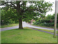
View of road junction from grass triangle
Image: © David Pashley
Taken: 1 Jun 2019
0.03 miles
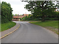
2
Looking North from near old Post Office
Image: © David Pashley
Taken: 9 Feb 2019
0.03 miles
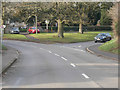
3
Watton to Swaffham road in Saham Toney
Image: © David Pashley
Taken: 1 Jun 2019
0.03 miles
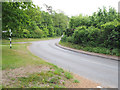
4
Heading towards Watton to Swaffham road down Pound Hill
Image: © David Pashley
Taken: 1 Jun 2019
0.03 miles
5
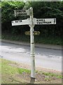
Direction Sign ? Signpost
Located on the west side of the junction of Richmond Road and Pound Hill in Saham Toney parish. 3 arms and cap finial.
Milestone Society National ID: NO_TF8901
Image: © J Young
Taken: 22 Jul 2004
0.04 miles
6
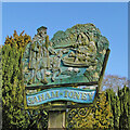
Saham Toney village sign
Roger de Toeni, after whom the village is named, is seen with his hound beside the mere in which locals are babbing for eels from their boat. Flag iris and water lilies decorate the scene.
Image: © Adrian S Pye
Taken: 17 Apr 2010
0.04 miles
7
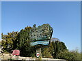
Saham Toney village sign
Roger de Toeni, after whom the village is named, is seen with his hound beside the mere in which locals are babbing for eels from their boat. Flag iris and water lilies decorate the scene. The crest on the post is that of the Hastings family.
Image: © Adrian S Pye
Taken: 17 Apr 2010
0.04 miles
8
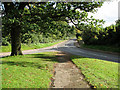
The green south of St George's church, Saham Toney
By the junction of Pound Hill (left) and Richmond Street. For a view of the church see > http://www.geograph.org.uk/photo/2114704.
Image: © Evelyn Simak
Taken: 16 Oct 2010
0.05 miles
9
St George's church, Saham Toney - C18 memorial
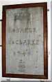
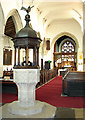
St George's church > http://www.geograph.org.uk/photo/2114704 is situated on an elevation north-west of Saham Mere* and dates mainly from the 15th century. Parts of the building are older, with the priest door dating from the 12th century and a c14 lancet window between the porch and the tower, indicating that the south aisle might be older than it appears to be. The church was extensively restored in 1864 but has retained a number of older features: the baptismal font > http://www.geograph.org.uk/photo/2114754 dates from the 15th century and its cover > http://www.geograph.org.uk/photo/2114756 is dated 1632. North aisle and nave still have their medieval roofs with coloured floral bosses. Most of the benches are Victorian but there are a number that have medieval carvings, interestingly all depicting lions > http://www.geograph.org.uk/photo/2114746 but each one of them different. The choir stall pews are original also, with carved poppyheads and ends > http://www.geograph.org.uk/photo/2114741. The chancel screen > http://www.geograph.org.uk/photo/2114736 dates from the same time, as does the 'wineglass' pulpit > http://www.geograph.org.uk/photo/2114732. It was restored and regilded in 1968 by the order of Woman Free Masons. The stained glass > http://www.geograph.org.uk/photo/2114743 in the church is Victorian.
* It is found on the top of a mound or rise, like 'craters' found on EDM discharges or caldareas on volcanos, near the Peddlars Way, an ancient path. The geological formation of Norfolk's meres is a puzzle as they fit no known formation process and a different theory is needed for each one. Saham Toney Mere is famous for its strange eels.
Image: © Evelyn Simak
Taken: 16 Oct 2010
0.05 miles
10
St George's church, Saham Toney - view east
St George's church > http://www.geograph.org.uk/photo/2114704 is situated on an elevation north-west of Saham Mere* and dates mainly from the 15th century. Parts of the building are older, with the priest door dating from the 12th century and a c14 lancet window between the porch and the tower, indicating that the south aisle might be older than it appears to be. The church was extensively restored in 1864 but has retained a number of older features: the baptismal font > http://www.geograph.org.uk/photo/2114754 dates from the 15th century and its cover > http://www.geograph.org.uk/photo/2114756 is dated 1632. North aisle and nave still have their medieval roofs with coloured floral bosses. Most of the benches are Victorian but there are a number that have medieval carvings, interestingly all depicting lions > http://www.geograph.org.uk/photo/2114746 but each one of them different. The choir stall pews are original also, with carved poppyheads and ends > http://www.geograph.org.uk/photo/2114741. The chancel screen > http://www.geograph.org.uk/photo/2114736 dates from the same time, as does the 'wineglass' pulpit > http://www.geograph.org.uk/photo/2114732. It was restored and regilded in 1968 by the order of Woman Free Masons. The stained glass >http://www.geograph.org.uk/photo/2114743 in the church is Victorian.
* It is found on the top of a mound or rise, like 'craters' found on EDM discharges or caldareas on volcanos, near the Peddlars Way, an ancient path. The geological formation of Norfolk's meres is a puzzle as they fit no known formation process and a different theory is needed for each one. Saham Toney Mere is famous for its strange eels.
Image: © Evelyn Simak
Taken: 16 Oct 2010
0.05 miles