IMAGES TAKEN NEAR TO
Woodlands, THETFORD, IP25 7AL
Introduction
This page details the photographs taken nearby to Woodlands, IP25 7AL by members of the Geograph project.
The Geograph project started in 2005 with the aim of publishing, organising and preserving representative images for every square kilometre of Great Britain, Ireland and the Isle of Man.

There are currently over 7.5m images from over14,400 individuals and you can help contribute to the project by visiting https://www.geograph.org.uk
Image Map
Images are licensed for reuse under creativecommons.org/licenses/by-sa/2.0
Notes
- Clicking on the map will re-center to the selected point.
- The higher the marker number, the further away the image location is from the centre of the postcode.
Image Listing (38 Images Found)
Images are licensed for reuse under creativecommons.org/licenses/by-sa/2.0
Image
Details
Distance
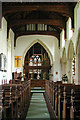
1
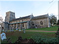
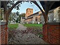
The Church of St Nicholas at Ashill
Viewed from the south-east.
Image: © Peter Wood
Taken: 10 Nov 2014
0.04 miles
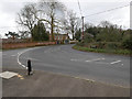
2
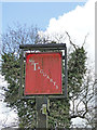
Sign for McTaggart's public house
https://www.geograph.org.uk/photo/6109631
Image: © Adrian S Pye
Taken: 4 Apr 2019
0.07 miles
3
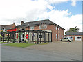
McTaggart's public house in Church Street, Ashill
Image: © Adrian S Pye
Taken: 4 Apr 2019
0.07 miles
5
St Nicholas Church, Ashill
Early morning sunlight touches the fine church at Ashill.
Image: © David Bremner
Taken: 29 Oct 2021
0.11 miles
8
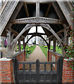
Looking through gate to Ashill Church
Image: © David Pashley
Taken: 13 Mar 2019
0.12 miles
9
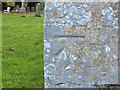
Ordnance Survey Cut Mark
This can be found on the wall of St Nicholas Church at Ashill.
For more detail see : http://www.bench-marks.org.uk/bm46562
Image: © Peter Wood
Taken: 10 Nov 2014
0.13 miles
10
St Nicholas, Ashill, Norfolk - East end
Image: © John Salmon
Taken: 29 May 2003
0.13 miles