IMAGES TAKEN NEAR TO
Shipdham Road, THETFORD, IP25 6SX
Introduction
This page details the photographs taken nearby to Shipdham Road, IP25 6SX by members of the Geograph project.
The Geograph project started in 2005 with the aim of publishing, organising and preserving representative images for every square kilometre of Great Britain, Ireland and the Isle of Man.

There are currently over 7.5m images from over14,400 individuals and you can help contribute to the project by visiting https://www.geograph.org.uk
Image Map
Images are licensed for reuse under creativecommons.org/licenses/by-sa/2.0
Notes
- Clicking on the map will re-center to the selected point.
- The higher the marker number, the further away the image location is from the centre of the postcode.
Image Listing (6 Images Found)
Images are licensed for reuse under creativecommons.org/licenses/by-sa/2.0
Image
Details
Distance
1
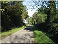
The Road To Shipdham
From Carbrooke.
Image: © Roger Gilbertson
Taken: 3 Nov 2006
0.08 miles
2
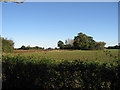
Typically Norfolk
Between Carbrooke and Shipdham.
Image: © Roger Gilbertson
Taken: 3 Nov 2006
0.08 miles
3
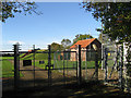
An Anglian Water Station
On Shipdham Road, Carbrooke.
Image: © Roger Gilbertson
Taken: 3 Nov 2006
0.08 miles
4
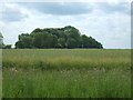
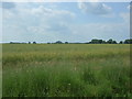
Cotteridge's Plantation
View over an oilseed rape crop.
Image: © JThomas
Taken: 17 Jun 2017
0.16 miles
6
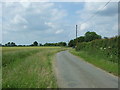
Shipdham Road
Heading north from Carbrooke.
Image: © JThomas
Taken: 17 Jun 2017
0.23 miles