IMAGES TAKEN NEAR TO
Drury Lane, THETFORD, IP25 6SJ
Introduction
This page details the photographs taken nearby to Drury Lane, IP25 6SJ by members of the Geograph project.
The Geograph project started in 2005 with the aim of publishing, organising and preserving representative images for every square kilometre of Great Britain, Ireland and the Isle of Man.

There are currently over 7.5m images from over14,400 individuals and you can help contribute to the project by visiting https://www.geograph.org.uk
Image Map
Images are licensed for reuse under creativecommons.org/licenses/by-sa/2.0
Notes
- Clicking on the map will re-center to the selected point.
- The higher the marker number, the further away the image location is from the centre of the postcode.
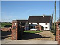
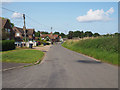
Image Listing (20 Images Found)
Images are licensed for reuse under creativecommons.org/licenses/by-sa/2.0
Image
Details
Distance
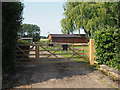
1
Tumbleweed
A house on Drury Lane, Carbrooke.
Image: © Roger Gilbertson
Taken: 3 Nov 2006
0.02 miles
4
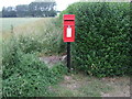
Elizabeth II postbox, Drurylane
Postbox No. IP25 3388.
Image: © JThomas
Taken: 17 Jun 2017
0.08 miles
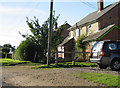
5
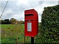
Postbox at Carbrooke
IP25 3388. Royal Mail list this box as 'IP25 (D) Drury Lane'.
Image: © David Bremner
Taken: 27 Oct 2022
0.09 miles