IMAGES TAKEN NEAR TO
Great Cressingham, THETFORD, IP25 6NS
Introduction
This page details the photographs taken nearby to IP25 6NS by members of the Geograph project.
The Geograph project started in 2005 with the aim of publishing, organising and preserving representative images for every square kilometre of Great Britain, Ireland and the Isle of Man.

There are currently over 7.5m images from over14,400 individuals and you can help contribute to the project by visiting https://www.geograph.org.uk
Image Map
Images are licensed for reuse under creativecommons.org/licenses/by-sa/2.0
Notes
- Clicking on the map will re-center to the selected point.
- The higher the marker number, the further away the image location is from the centre of the postcode.
Image Listing (32 Images Found)
Images are licensed for reuse under creativecommons.org/licenses/by-sa/2.0
Image
Details
Distance
1
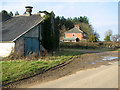
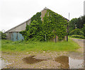
Fairstead, Little Cressingham
The cottage is situated by the junction of Fairstead Lane with an unnamed road that links the villages Little and Great Cressingham. The woodland adjoining it is Southwater Plantation.
Image: © Evelyn Simak
Taken: 31 Jan 2011
0.01 miles
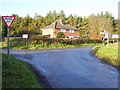
2
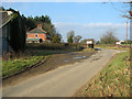
Road junction by Fairstead
This area is situated on the eastern fringe of the Battle Training Area and there are many signs announcing military training areas. The text on the two rectangular signs seen by the junction of Fairstead Lane (and an unnamed lane that links the villages of Little and Great Cressingham) says "No Entry for Military Vehicles ahead".
Image: © Evelyn Simak
Taken: 31 Jan 2011
0.01 miles
3
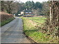
Fairstead, Little Cressingham
The cottage is situated by the junction of Fairstead Lane (seen in the foreground) and an unnamed lane that links the villages of Little and Great Cressingham. The woodland adjoining the property is Southwater Plantation.
Image: © Evelyn Simak
Taken: 31 Jan 2011
0.01 miles
4
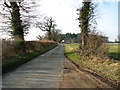
Approaching Fairstead on Fairstead Lane
The cottage is situated by the junction of Fairstead Lane (seen in the foreground) and an unnamed lane that links the villages of Little and Great Cressingham. The woodland adjoining the property is Southwater Plantation.
Image: © Evelyn Simak
Taken: 31 Jan 2011
0.01 miles
5
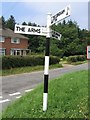
Direction Sign ? Signpost
Located on the northeast side of the junction of Great Cressingham Road and Fairstead Lane in Little Cressingham parish. 3 arms, 1 missing, and cap finial.
See also (Cols DH, DI and DK).
Milestone Society National ID: NO_TF8500
Image: © J Young
Taken: 2 Aug 2004
0.02 miles

7
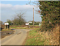
No Entry for Military Vehicles ahead
This area is situated on the eastern fringe of the Battle Training Area and there are many signs announcing military training areas. The text on the two rectangular signs seen by the junction of Fairstead Lane (and an unnamed lane that links the villages of Little and Great Cressingham) says "No Entry for Military Vehicles ahead".
Image: © Evelyn Simak
Taken: 31 Jan 2011
0.02 miles
10
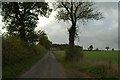
"The Fairsteads"
Known locally as the Fairsteads, this is the junction of Fairstead Lane and the road to Great Cressingham.
Image: © Paul Turner
Taken: 21 Nov 2006
0.03 miles