IMAGES TAKEN NEAR TO
Threxton, THETFORD, IP25 6LU
Introduction
This page details the photographs taken nearby to IP25 6LU by members of the Geograph project.
The Geograph project started in 2005 with the aim of publishing, organising and preserving representative images for every square kilometre of Great Britain, Ireland and the Isle of Man.

There are currently over 7.5m images from over14,400 individuals and you can help contribute to the project by visiting https://www.geograph.org.uk
Image Map
Images are licensed for reuse under creativecommons.org/licenses/by-sa/2.0
Notes
- Clicking on the map will re-center to the selected point.
- The higher the marker number, the further away the image location is from the centre of the postcode.
Image Listing (55 Images Found)
Images are licensed for reuse under creativecommons.org/licenses/by-sa/2.0
Image
Details
Distance
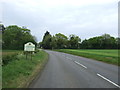
1
Elizabeth II postbox, Threxton
Postbox No. IP25 3329.
See Image] for close up.
Image: © JThomas
Taken: 13 May 2017
0.04 miles
2
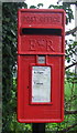
Close up, Elizabeth II postbox, Threxton
Postbox No. IP25 3329.
See Image] for detail.
Image: © JThomas
Taken: 13 May 2017
0.04 miles
3
Peddars Way along the B1108 Watton Road
Image: © Mat Fascione
Taken: 29 May 2017
0.05 miles
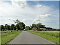
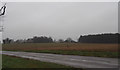
4
Entering Threxton
Looking east on Watton Road (B1108)
Image: © JThomas
Taken: 13 May 2017
0.07 miles
6
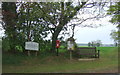
Field, Thexton Hill
Distant view towards Threxton All Saints Church. Image]
Image: © JThomas
Taken: 13 May 2017
0.10 miles
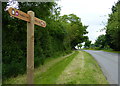
7
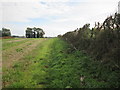
Peddars Way on field edge footpath
On the other side of the hedge is the B1108 a fast road toward Watton.
Image: © Martin Dawes
Taken: 15 Sep 2018
0.13 miles
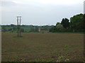
9
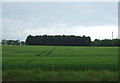
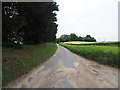
Crop field, Threxton Hill
Looking south from the B1108 towards Oak Wood.
Image: © JThomas
Taken: 13 May 2017
0.14 miles