IMAGES TAKEN NEAR TO
Hendon Avenue, THETFORD, IP25 6JW
Introduction
This page details the photographs taken nearby to Hendon Avenue, IP25 6JW by members of the Geograph project.
The Geograph project started in 2005 with the aim of publishing, organising and preserving representative images for every square kilometre of Great Britain, Ireland and the Isle of Man.

There are currently over 7.5m images from over14,400 individuals and you can help contribute to the project by visiting https://www.geograph.org.uk
Image Map
Images are licensed for reuse under creativecommons.org/licenses/by-sa/2.0
Notes
- Clicking on the map will re-center to the selected point.
- The higher the marker number, the further away the image location is from the centre of the postcode.
Image Listing (9 Images Found)
Images are licensed for reuse under creativecommons.org/licenses/by-sa/2.0
Image
Details
Distance
2
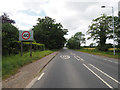
Norwich Road (B1108) towards Hingham
Looking east.
Image: © JThomas
Taken: 13 May 2017
0.05 miles
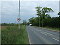
3
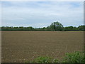
Field, Shrublands
North of Norwich Road (B1108).
Image: © JThomas
Taken: 13 May 2017
0.06 miles
4
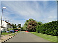
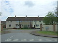
Hendon Avenue, Watton
Most of the roads on this ex-married quarters are names after other RAF stations. Biggin Hill Way, Farnborough Road, Cranwell Road Etc.
Image: © Adrian S Pye
Taken: 22 May 2019
0.09 miles
5
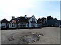
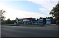
The Flying Fish pub, Watton
On the outskirts of Watton in a semi-industrial area. It used to be called the White Horse.
Image: © Bikeboy
Taken: 13 Apr 2015
0.12 miles
6
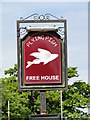
The sign of The Flying Fish
https://www.geograph.org.uk/photo/6159910
Image: © Adrian S Pye
Taken: 22 May 2019
0.12 miles
7
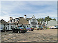
The Flying Fish public house and restaurant
https://www.geograph.org.uk/photo/6159912
Image: © Adrian S Pye
Taken: 22 May 2019
0.12 miles
8
Aerolite Garage on Norwich Road, Watton
Image: © David Howard
Taken: 19 Jul 2020
0.19 miles