IMAGES TAKEN NEAR TO
Railway Mews, THETFORD, IP25 6GL
Introduction
This page details the photographs taken nearby to Railway Mews, IP25 6GL by members of the Geograph project.
The Geograph project started in 2005 with the aim of publishing, organising and preserving representative images for every square kilometre of Great Britain, Ireland and the Isle of Man.

There are currently over 7.5m images from over14,400 individuals and you can help contribute to the project by visiting https://www.geograph.org.uk
Image Map
Images are licensed for reuse under creativecommons.org/licenses/by-sa/2.0
Notes
- Clicking on the map will re-center to the selected point.
- The higher the marker number, the further away the image location is from the centre of the postcode.
Image Listing (102 Images Found)
Images are licensed for reuse under creativecommons.org/licenses/by-sa/2.0
Image
Details
Distance
3
Church Walk at Watton
This pathway connects Church Road with Cadman Way.
Image: © Robert Edwards
Taken: 16 May 2012
0.07 miles
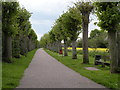
4
Church Walk, Watton
Tree lined walk - looking west.
Image: © JThomas
Taken: 13 May 2017
0.07 miles
5
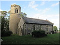
St Mary's Parish Church Watton (3)
There is an O/S bench mark on the buttress to the right
Image: © Martin Dawes
Taken: 14 Sep 2018
0.07 miles
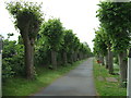
6
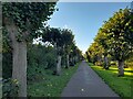
Church Walk, Watton
The lime trees were planted to commemorate the Coronation of King Edward VII in 1902.
Image: © David Bremner
Taken: 28 Oct 2021
0.07 miles
7
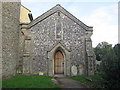
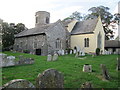
St Mary's Parish Church Watton (1)
One of Norfolk's many round towered churches
Image: © Martin Dawes
Taken: 14 Sep 2018
0.07 miles
8
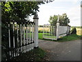
Gates at the entrance to Church Walk
This runs through to Cadman Way the A1075
Image: © Martin Dawes
Taken: 14 Sep 2018
0.08 miles
10
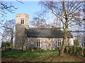
St. Mary's church, Watton
I was fortunate to find the church open on my third visit due to a funeral taking place, no keyholder, usually locked and inhospitable. The tower is Norman with a later upper stage and parapet. The south arcade is 14th c. but much restoration and re-building has destroyed much of its appeal. The 15th c. font has geometric patterns carved around the bowl. In the nave, attached to a pillar is a unique poor-man’s box dated, a carved wooden figure holding out his hand with a slot in his wrist for the offering. On his chest is written ‘Remember the poore-1639’ The nave itself is quite well lit but some nice Victorian wood carving can be found in dark corners and on the handrail of the pulpit and readers desk. Behind the altar rail is a sedilia, on its left is a piscina bowl cut directly into the sill.
Image: © Adrian S Pye
Taken: 5 Feb 2010
0.08 miles