IMAGES TAKEN NEAR TO
Charles Avenue, THETFORD, IP25 6BZ
Introduction
This page details the photographs taken nearby to Charles Avenue, IP25 6BZ by members of the Geograph project.
The Geograph project started in 2005 with the aim of publishing, organising and preserving representative images for every square kilometre of Great Britain, Ireland and the Isle of Man.

There are currently over 7.5m images from over14,400 individuals and you can help contribute to the project by visiting https://www.geograph.org.uk
Image Map
Images are licensed for reuse under creativecommons.org/licenses/by-sa/2.0
Notes
- Clicking on the map will re-center to the selected point.
- The higher the marker number, the further away the image location is from the centre of the postcode.
Image Listing (53 Images Found)
Images are licensed for reuse under creativecommons.org/licenses/by-sa/2.0
Image
Details
Distance
7
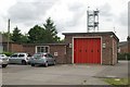
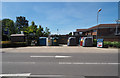
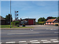
Watton fire station
Watton fire station, Thetford Road, Watton, Norfolk
Image: © Kevin Hale
Taken: 6 Jun 2009
0.12 miles
8
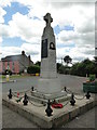
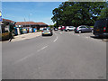
Watton War Memorial
The memorial bears 30 names relating to WW1 and on the plaque are 17 names relating to WW2.
In the churchyard are the Commonwealth War Graves of another 38 men primarily from RAF station Watton.
Image: © Adrian S Pye
Taken: 6 Jul 2016
0.12 miles
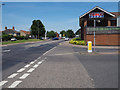
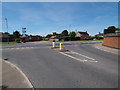
10
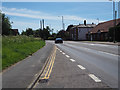
A1075 and B1108 cross roads in Watton
Image: © David Pashley
Taken: 21 Apr 2019
0.15 miles