IMAGES TAKEN NEAR TO
Warren Close, THETFORD, IP24 3NL
Introduction
This page details the photographs taken nearby to Warren Close, IP24 3NL by members of the Geograph project.
The Geograph project started in 2005 with the aim of publishing, organising and preserving representative images for every square kilometre of Great Britain, Ireland and the Isle of Man.

There are currently over 7.5m images from over14,400 individuals and you can help contribute to the project by visiting https://www.geograph.org.uk
Image Map
Images are licensed for reuse under creativecommons.org/licenses/by-sa/2.0
Notes
- Clicking on the map will re-center to the selected point.
- The higher the marker number, the further away the image location is from the centre of the postcode.
Image Listing (18 Images Found)
Images are licensed for reuse under creativecommons.org/licenses/by-sa/2.0
Image
Details
Distance
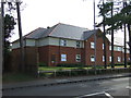
4
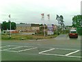
The Warrener, Thetford
Modern pub surrounded by new houses: the Warrener is associated with a Premier Inn.
Image: © Stephen McKay
Taken: 15 Dec 2012
0.14 miles
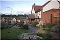
5

The Warrener, Thetford
Public house on the A134, next to the Premier Inn.
Image: © JThomas
Taken: 16 Jul 2015
0.14 miles

7
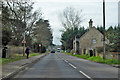
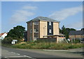
A134 Brandon Road, Thetford
What looks deceptively like a toll house on the right is actually a pair of estate cottages, 1860, grade II listed.
Image: © Robin Webster
Taken: 7 Mar 2020
0.15 miles