IMAGES TAKEN NEAR TO
St. Michaels Close, THETFORD, IP24 3EH
Introduction
This page details the photographs taken nearby to St. Michaels Close, IP24 3EH by members of the Geograph project.
The Geograph project started in 2005 with the aim of publishing, organising and preserving representative images for every square kilometre of Great Britain, Ireland and the Isle of Man.

There are currently over 7.5m images from over14,400 individuals and you can help contribute to the project by visiting https://www.geograph.org.uk
Image Map
Images are licensed for reuse under creativecommons.org/licenses/by-sa/2.0
Notes
- Clicking on the map will re-center to the selected point.
- The higher the marker number, the further away the image location is from the centre of the postcode.
Image Listing (98 Images Found)
Images are licensed for reuse under creativecommons.org/licenses/by-sa/2.0
Image
Details
Distance
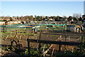
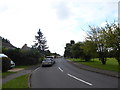
2
Approaching the junction of Nuns' Bridges Road and Nunnery Drive
Image: © Basher Eyre
Taken: 17 Sep 2017
0.09 miles
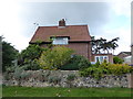
4
Nunnery Drive: guess who lives here?
Well did. A lot of these have been sold off, I'm afraid
Image: © Basher Eyre
Taken: 17 Sep 2017
0.10 miles
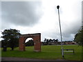
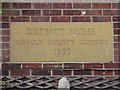
7
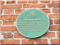
Plaque on the Nunnery Arch
Also see http://www.britishlistedbuildings.co.uk/101207969-nunnery-gateway-thetford
Image: © Basher Eyre
Taken: 17 Sep 2017
0.10 miles
9

Scania R480 near Thetford
Scania R480 (Ay12 AFE) travelling north on the A134 at Thetford.
Image: © David Dixon
Taken: 6 Aug 2015
0.11 miles
