
IMAGES TAKEN NEAR TO
Bury Road, THETFORD, IP24 3DD
Introduction
This page details the photographs taken nearby to Bury Road, IP24 3DD by members of the Geograph project.
The Geograph project started in 2005 with the aim of publishing, organising and preserving representative images for every square kilometre of Great Britain, Ireland and the Isle of Man.

There are currently over 7.5m images from over14,400 individuals and you can help contribute to the project by visiting https://www.geograph.org.uk
Image Map
Images are licensed for reuse under creativecommons.org/licenses/by-sa/2.0
Notes
- Clicking on the map will re-center to the selected point.
- The higher the marker number, the further away the image location is from the centre of the postcode.
Image Listing (286 Images Found)
Images are licensed for reuse under creativecommons.org/licenses/by-sa/2.0
Image
Details
Distance
2

St Mary the Less in Thetford - overgrown churchyard
For a view of this disused and neglected church see > http://www.geograph.org.uk/photo/2023934.
Image: © Evelyn Simak
Taken: 20 Aug 2010
0.04 miles
3
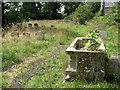
St Mary the Less in Thetford - path through churchyard
For a view of this disused and neglected church see > http://www.geograph.org.uk/photo/2023934.
Image: © Evelyn Simak
Taken: 20 Aug 2010
0.04 miles
6
![Thetford houses [20]](https://s1.geograph.org.uk/geophotos/06/71/63/6716325_86fbf549_120x120.jpg)
Thetford houses [20]
Numbers 12 and 16 Mill Lane were originally a row of three houses, now two with number 14 being incorporated into number 16. Built in the mid 19th century in flint with gault brick dressings, altered in the late 20th century when some large extensions were added at the rear. Listed, grade II, with details at: https://historicengland.org.uk/listing/the-list/list-entry/1207900
Once the ancient capital of East Anglia, Thetford is a market town established at a crossing of the River Little Ouse. A major centre of Boudica’s Iceni tribe with an Iron Age fort. Later came a Norman castle and an important priory. Thetford is the birthplace of 18th century radical Thomas Paine, whose thinking encouraged American independence and the abolition of slavery. After World War II, Thetford became an "overspill town", taking people from London.
Image: © Michael Dibb
Taken: 8 Sep 2020
0.04 miles
7

St Mary the Less in Thetford - the porch
For a view of this disused and neglected church see > http://www.geograph.org.uk/photo/2023934.
Image: © Evelyn Simak
Taken: 20 Aug 2010
0.05 miles
8

St Mary the Less in Thetford - disused and neglected
Of the 21 medieval churches that once existed in Thetford only three are still standing. St Mary the Less > http://www.geograph.org.uk/photo/2023934 in Old Bury Road is the oldest of the three. The Grade II listed building was declared redundant in 1975 and sold to a private developer. It has since changed ownership several times without any work having been done to it. The windows are boarded up > http://www.geograph.org.uk/photo/2023961 and the stained glass panels > http://www.geograph.org.uk/photo/2023964 still contained therein appear to have been smashed from within. Ever since a section of the north aisle roof has collapsed a flock of feral pigeons > http://www.geograph.org.uk/photo/2023967 has moved in, causing further damage to the structure. The churchyard is reverting back to a wilderness, with brambles growing against the south wall, covering old monuments > http://www.geograph.org.uk/photo/2023957 placed there. The structure has recently been included in both English Heritage's and Norfolk County Council's list of Buildings at Risk, in an effort that something may soon be done to stop the ongoing dereliction.
Image: © Evelyn Simak
Taken: 20 Aug 2010
0.05 miles
9

St Mary the Less in Thetford - overgrown memorials
For a view of this disused and neglected church see > http://www.geograph.org.uk/photo/2023934.
Image: © Evelyn Simak
Taken: 20 Aug 2010
0.05 miles
10
![Thetford houses [17]](https://s3.geograph.org.uk/geophotos/06/71/53/6715371_5fde0614_120x120.jpg)
Thetford houses [17]
Number 37 Bury Road was built in the 1830s in galleted flint with gault brick dressings. The house was used as a veterinary surgery for some years in the late 20th century. Listed, grade II, with details at: https://historicengland.org.uk/listing/the-list/list-entry/1279709
Once the ancient capital of East Anglia, Thetford is a market town established at a crossing of the River Little Ouse. A major centre of Boudica’s Iceni tribe with an Iron Age fort. Later came a Norman castle and an important priory. Thetford is the birthplace of 18th century radical Thomas Paine, whose thinking encouraged American independence and the abolition of slavery. After World War II, Thetford became an "overspill town", taking people from London.
Image: © Michael Dibb
Taken: 8 Sep 2020
0.05 miles