IMAGES TAKEN NEAR TO
Rosecroft Way, THETFORD, IP24 2XR
Introduction
This page details the photographs taken nearby to Rosecroft Way, IP24 2XR by members of the Geograph project.
The Geograph project started in 2005 with the aim of publishing, organising and preserving representative images for every square kilometre of Great Britain, Ireland and the Isle of Man.

There are currently over 7.5m images from over14,400 individuals and you can help contribute to the project by visiting https://www.geograph.org.uk
Image Map
Images are licensed for reuse under creativecommons.org/licenses/by-sa/2.0
Notes
- Clicking on the map will re-center to the selected point.
- The higher the marker number, the further away the image location is from the centre of the postcode.
Image Listing (6 Images Found)
Images are licensed for reuse under creativecommons.org/licenses/by-sa/2.0
Image
Details
Distance
1
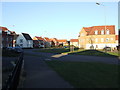
Charlock Road
Looking northeast along Charlock Road Thetford, Norfolk.
Image: © Keith Evans
Taken: 18 Jan 2009
0.08 miles
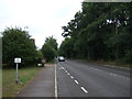
2
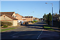
Rosecroft Way
Part of a very area of new housing on the edge of Thetford. Looking north east from the junction with Caraway Road.
Image: © Bill Boaden
Taken: 28 Dec 2013
0.18 miles
3
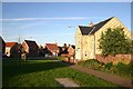
Cloverfields Estate, Thetford
Modern housing development on the east side of the town.
Image: © Bob Jones
Taken: 3 Nov 2006
0.19 miles
4
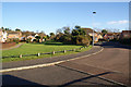
Campion Road, Thetford
Part of a large development of new housing. It was built on a greenfield site, and some green space has been retained.
Image: © Bill Boaden
Taken: 28 Dec 2013
0.21 miles
6
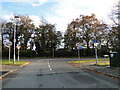
Approaching the A1074 from Churchill Road
Image: © Adrian S Pye
Taken: 13 Nov 2018
0.24 miles