IMAGES TAKEN NEAR TO
Memorial Bungalows, THETFORD, IP24 2QH
Introduction
This page details the photographs taken nearby to Memorial Bungalows, IP24 2QH by members of the Geograph project.
The Geograph project started in 2005 with the aim of publishing, organising and preserving representative images for every square kilometre of Great Britain, Ireland and the Isle of Man.

There are currently over 7.5m images from over14,400 individuals and you can help contribute to the project by visiting https://www.geograph.org.uk
Image Map
Images are licensed for reuse under creativecommons.org/licenses/by-sa/2.0
Notes
- Clicking on the map will re-center to the selected point.
- The higher the marker number, the further away the image location is from the centre of the postcode.
Image Listing (62 Images Found)
Images are licensed for reuse under creativecommons.org/licenses/by-sa/2.0
Image
Details
Distance
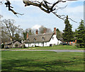
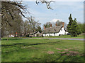
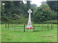
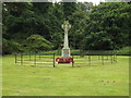
1
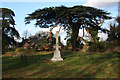
War memorial, Euston
Viewed from the entrance to Euston Hall, the war memorial stands on a small green between the Hall and a row of thatched cottages.
Image: © Bob Jones
Taken: 27 Nov 2009
0.01 miles
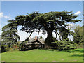
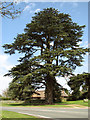
4

Magnificent tree at Euston
This tall tree stands next to the A1088 at Euston, close to the war memorial.
Image: © Bob Jones
Taken: 27 Nov 2009
0.02 miles
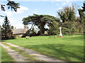
6
Euston War Memorial
War memorial Euston Suffolk.
Image: © Keith Evans
Taken: 31 Aug 2008
0.03 miles
9
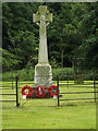
Euston War Memorial
Off the A1088 Thetford Road
(Close up)
Image: © Geographer
Taken: 18 Jun 2016
0.03 miles
10
Euston War Memorial
Off the A1088 Thetford Road
Image: © Geographer
Taken: 18 Jun 2016
0.03 miles