IMAGES TAKEN NEAR TO
Euston Road, THETFORD, IP24 2QD
Introduction
This page details the photographs taken nearby to Euston Road, IP24 2QD by members of the Geograph project.
The Geograph project started in 2005 with the aim of publishing, organising and preserving representative images for every square kilometre of Great Britain, Ireland and the Isle of Man.

There are currently over 7.5m images from over14,400 individuals and you can help contribute to the project by visiting https://www.geograph.org.uk
Image Map
Images are licensed for reuse under creativecommons.org/licenses/by-sa/2.0
Notes
- Clicking on the map will re-center to the selected point.
- The higher the marker number, the further away the image location is from the centre of the postcode.
Image Listing (6 Images Found)
Images are licensed for reuse under creativecommons.org/licenses/by-sa/2.0
Image
Details
Distance
1
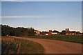
Great Snarehill Belt
Farm buildings south-east of Thetford.
Image: © Bob Jones
Taken: 3 Nov 2006
0.06 miles
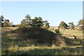
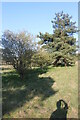
2
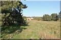
Field in Euston
Complete with an ancient ruin
Image: © David Howard
Taken: 18 Apr 2021
0.17 miles
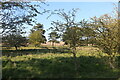

6
Field in Euston
Once you leave the farm track most of the field is in TL8981
Image: © David Howard
Taken: 18 Apr 2021
0.23 miles