
IMAGES TAKEN NEAR TO
Raymond Street, THETFORD, IP24 2EB
Introduction
This page details the photographs taken nearby to Raymond Street, IP24 2EB by members of the Geograph project.
The Geograph project started in 2005 with the aim of publishing, organising and preserving representative images for every square kilometre of Great Britain, Ireland and the Isle of Man.

There are currently over 7.5m images from over14,400 individuals and you can help contribute to the project by visiting https://www.geograph.org.uk
Image Map
Images are licensed for reuse under creativecommons.org/licenses/by-sa/2.0
Notes
- Clicking on the map will re-center to the selected point.
- The higher the marker number, the further away the image location is from the centre of the postcode.
Image Listing (768 Images Found)
Images are licensed for reuse under creativecommons.org/licenses/by-sa/2.0
Image
Details
Distance
1
![Thetford buildings [47]](https://s2.geograph.org.uk/geophotos/06/71/89/6718998_591bcc51_120x120.jpg)
Thetford buildings [47]
Now partly converted, these maltings fronting Raymond Street were built in 18661 on the site of earlier maltings from 1769. There are two parallel blocks linked by a cross wing. The main block to Raymond Street is warehouse and manufactory, the smaller block is maltings. Constructed with a flint facing to clunch and brick walls with red and gault brick dressings. The building was altered in 1967 and in 1989 when it was partly converted to offices and altered again in 1999 for a youth centre. Listed, grade II. with details at: https://historicengland.org.uk/listing/the-list/list-entry/1196083
Once the ancient capital of East Anglia, Thetford is a market town established at a crossing of the River Little Ouse. A major centre of Boudica’s Iceni tribe with an Iron Age fort. Later came a Norman castle and an important priory. Thetford is the birthplace of 18th century radical Thomas Paine, whose thinking encouraged American independence and the abolition of slavery. After World War II, Thetford became an "overspill town", taking people from London.
Image: © Michael Dibb
Taken: 8 Sep 2020
0.02 miles
2
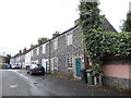
Familiar cottages in Nether Row
Also see http://www.literarynorfolk.co.uk/dad%27s_army.htm
Image: © Basher Eyre
Taken: 16 Sep 2017
0.02 miles
3
![Thetford houses [33]](https://s0.geograph.org.uk/geophotos/06/71/89/6718996_bb47768d_120x120.jpg)
Thetford houses [33]
The Old Rectory, number 30 Raymond Street, was built in the early 19th century. Constructed in flint with gault brick dressings and a gault brick front. Listed, grade II, with details at: https://historicengland.org.uk/listing/the-list/list-entry/1219142
Once the ancient capital of East Anglia, Thetford is a market town established at a crossing of the River Little Ouse. A major centre of Boudica’s Iceni tribe with an Iron Age fort. Later came a Norman castle and an important priory. Thetford is the birthplace of 18th century radical Thomas Paine, whose thinking encouraged American independence and the abolition of slavery. After World War II, Thetford became an "overspill town", taking people from London.
Image: © Michael Dibb
Taken: 8 Sep 2020
0.03 miles
4
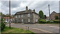
The Old Rectory, 30 Raymond Street, Thetford
https://historicengland.org.uk/listing/the-list/list-entry/1219142?section=official-list-entry
Image: © Sandy Gerrard
Taken: 2 May 2023
0.03 miles
5
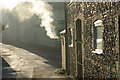
Nether Row, Thetford
A Thetford back street seen on a very cold morning; note the characteristic flint-faced building on the right.
Image: © Stephen McKay
Taken: 7 Dec 2008
0.04 miles
6
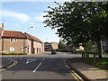
Guildhall Street, Thetford
At the junction with Rampart Way, Raymond Street, Nether Road and Old Market Street.
Image: © Geographer
Taken: 4 Jun 2016
0.04 miles
7
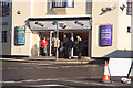
Queueing for morning bingo
Bingo sessions are held at the former cinema on the corner of Guildhall Street and Rampart Way. Just as I took the photo from Nether Row the doors opened and the small queue started to move inside.
Image: © Bob Jones
Taken: 31 Oct 2008
0.04 miles
8
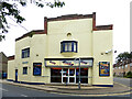
Winners Bingo
Winners Bingo is located at the SE end of Guildhall Street. Viewed on a disappointingly dull summer afternoon.
Image: © Mary and Angus Hogg
Taken: 29 Aug 2021
0.04 miles
9
![Thetford houses [32]](https://s3.geograph.org.uk/geophotos/06/71/89/6718991_addb2a2c_120x120.jpg)
Thetford houses [32]
Numbers 6 and 8 Raymond Street are two late 18th century houses. Number 6 has a long rear range, numbered 6A to 6D, extending along Nether Row and used as offices. Constructed in flint with red brick dressings and colourwashed brick fronts. Listed, grade II, with details at: https://historicengland.org.uk/listing/the-list/list-entry/1297825
Number 10 Raymond Street is a house and shop, built circa 1820 in flint with a colourwashed brick front. Listed, grade II, with details at: https://historicengland.org.uk/listing/the-list/list-entry/1196082
Once the ancient capital of East Anglia, Thetford is a market town established at a crossing of the River Little Ouse. A major centre of Boudica’s Iceni tribe with an Iron Age fort. Later came a Norman castle and an important priory. Thetford is the birthplace of 18th century radical Thomas Paine, whose thinking encouraged American independence and the abolition of slavery. After World War II, Thetford became an "overspill town", taking people from London.
Image: © Michael Dibb
Taken: 8 Sep 2020
0.06 miles
10
![Thetford buildings [46]](https://s2.geograph.org.uk/geophotos/06/71/89/6718994_a30fadb9_120x120.jpg)
Thetford buildings [46]
Number 11 Raymond Street, now a restaurant, was built as two houses, later a house, a shop and an office. Constructed in the mid 19th century, on a corner site, in gault brick. Listed, grade II, with details at: https://historicengland.org.uk/listing/the-list/list-entry/1297826
Once the ancient capital of East Anglia, Thetford is a market town established at a crossing of the River Little Ouse. A major centre of Boudica’s Iceni tribe with an Iron Age fort. Later came a Norman castle and an important priory. Thetford is the birthplace of 18th century radical Thomas Paine, whose thinking encouraged American independence and the abolition of slavery. After World War II, Thetford became an "overspill town", taking people from London.
Image: © Michael Dibb
Taken: 8 Sep 2020
0.06 miles