IMAGES TAKEN NEAR TO
IP24 1QU
Introduction
This page details the photographs taken nearby to IP24 1QU by members of the Geograph project.
The Geograph project started in 2005 with the aim of publishing, organising and preserving representative images for every square kilometre of Great Britain, Ireland and the Isle of Man.

There are currently over 7.5m images from over14,400 individuals and you can help contribute to the project by visiting https://www.geograph.org.uk
Image Map
Images are licensed for reuse under creativecommons.org/licenses/by-sa/2.0
Notes
- Clicking on the map will re-center to the selected point.
- The higher the marker number, the further away the image location is from the centre of the postcode.
Image Listing (10 Images Found)
Images are licensed for reuse under creativecommons.org/licenses/by-sa/2.0
Image
Details
Distance
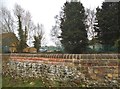
1
East Wretham Ordnance Survey Trig Pillar
Inside Wretham A Camp
Image: © Siobhan Brennan-Raymond
Taken: 10 Aug 2010
0.08 miles
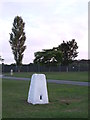
2
Sentry box and Fire Point at Wretham 'A' Camp
http://www.geograph.org.uk/photo/5025158
Image: © Adrian S Pye
Taken: 6 Jul 2016
0.10 miles
3
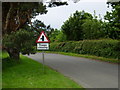
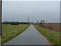
Road past Wretham Camp
This unusual sign warns motorists of the entrance to the army camp at Wretham.
Image: © Stephen McKay
Taken: 4 Jun 2006
0.11 miles
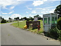
4
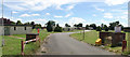
Wretham 'A' Camp from the entrance
Now deserted, east Wretham airfield was hurriedly brought into service during the early years of World War II as a satellite airfield with No. 311 (Czech) Squadron dispersed there from RAF Honington in July 1940. No hard runway was ever laid.
East Wretham churchyard has 16 graves of those who died while serving at the station.
After the war ended, the airfield was briefly used by the RAF as a Polish resettlement camp, and STANTA (Stanford Practical Training Area) finally took over possession until its closure.
Image: © Adrian S Pye
Taken: 6 Jul 2016
0.11 miles
6
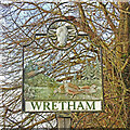
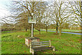
Wretham village sign
The sign is surmounted by a Ram’s head remembering that at one time a ram was released in a barley field after the harvest and whoever caught it was allowed to keep it. The ram was donated by Eton college which manorial rights at the time. The pine trees and the grey partridges represent all the local flora and fauna. The sharp-eyed will notice one of the partridges is investigating a beetle, locally called a chovy of which there are many, otherwise known as cockchafers. The presence of the witch is a bit of a mystery and probably included for a bit of fun although many parishes had traditions of witchcraft in the middle ages, some of which persisted into the last century.
Image: © Adrian S Pye
Taken: 22 Nov 2020
0.18 miles
7
Wretham village sign
The sign is surmounted by a Ram’s head remembering that at one time a ram was released in a barley field after the harvest and whoever caught it was allowed to keep it. The ram was donated by Eton college which manorial rights at the time. The pine trees and the grey partridges represent all the local flora and fauna. The sharp-eyed will notice one of the partridges is investigating a beetle, locally called a chovy of which there are many, otherwise known as cockchafers. The presence of the witch is a bit of a mystery and probably included for a bit of fun although many parishes had traditions of witchcraft in the middle ages, some of which persisted into the last century.
Image: © Adrian S Pye
Taken: 22 Nov 2020
0.18 miles
8
Wretham 'A' Camp
Looking towards Wretham 'A' camp as marked on the 1:50:000 O.S. map Wretham Norfolk.
Image: © Keith Evans
Taken: 11 Feb 2007
0.22 miles
9
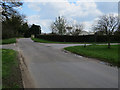
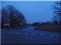
Crossroads near Wretham 'A' Camp
On the edge of the STANTA training area.
Image: © Hugh Venables
Taken: 17 Apr 2016
0.24 miles