1
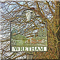
Wretham village sign
The sign is surmounted by a Ram’s head remembering that at one time a ram was released in a barley field after the harvest and whoever caught it was allowed to keep it. The ram was donated by Eton college which manorial rights at the time. The pine trees and the grey partridges represent all the local flora and fauna. The sharp-eyed will notice one of the partridges is investigating a beetle, locally called a chovy of which there are many, otherwise known as cockchafers. The presence of the witch is a bit of a mystery and probably included for a bit of fun although many parishes had traditions of witchcraft in the middle ages, some of which persisted into the last century.
Image: © Adrian S Pye
Taken: 22 Nov 2020
0.09 miles
2
Wretham village sign
The sign is surmounted by a Ram’s head remembering that at one time a ram was released in a barley field after the harvest and whoever caught it was allowed to keep it. The ram was donated by Eton college which manorial rights at the time. The pine trees and the grey partridges represent all the local flora and fauna. The sharp-eyed will notice one of the partridges is investigating a beetle, locally called a chovy of which there are many, otherwise known as cockchafers. The presence of the witch is a bit of a mystery and probably included for a bit of fun although many parishes had traditions of witchcraft in the middle ages, some of which persisted into the last century.
Image: © Adrian S Pye
Taken: 22 Nov 2020
0.09 miles
3
Junction on Thetford Road, Wretham
Image: © David Howard
Taken: 24 Mar 2018
0.10 miles
4
Wretham 'A' Camp from the entrance
Now deserted, east Wretham airfield was hurriedly brought into service during the early years of World War II as a satellite airfield with No. 311 (Czech) Squadron dispersed there from RAF Honington in July 1940. No hard runway was ever laid.
East Wretham churchyard has 16 graves of those who died while serving at the station.
After the war ended, the airfield was briefly used by the RAF as a Polish resettlement camp, and STANTA (Stanford Practical Training Area) finally took over possession until its closure.
Image: © Adrian S Pye
Taken: 6 Jul 2016
0.14 miles
5
Road past Wretham Camp
This unusual sign warns motorists of the entrance to the army camp at Wretham.
Image: © Stephen McKay
Taken: 4 Jun 2006
0.14 miles
6
Sentry box and Fire Point at Wretham 'A' Camp
http://www.geograph.org.uk/photo/5025158
Image: © Adrian S Pye
Taken: 6 Jul 2016
0.16 miles
7
Railway Bridge
Here next to the Peddars way in Norfolk is an old railway bridge of which the railway has been gone for some considerable amount of years The Railway was once the Bury Thetford and Swaffham railway, though looking on an old 1930's OS map it appears just to run from Roundham to Swaffham probably taken over by the Great Eastern Railway and so to British Rail Eastern region in 1947
Image: © Ant Basterfield
Taken: 2 Jul 2016
0.23 miles
8
Field glimpsed through a gap on the Peddars Way
Image: © Basher Eyre
Taken: 25 Sep 2021
0.24 miles
9
Rearing units at Bridge Farm
The first of many such buildings at this farm, from access track and route of Peddars Way
Image: © Martin Dawes
Taken: 15 Sep 2018
0.24 miles
10
Chickens spotted from the Peddars Way
Image: © Basher Eyre
Taken: 25 Sep 2021
0.24 miles


