IMAGES TAKEN NEAR TO
Windmill Lane, THETFORD, IP24 1QR
Introduction
This page details the photographs taken nearby to Windmill Lane, IP24 1QR by members of the Geograph project.
The Geograph project started in 2005 with the aim of publishing, organising and preserving representative images for every square kilometre of Great Britain, Ireland and the Isle of Man.

There are currently over 7.5m images from over14,400 individuals and you can help contribute to the project by visiting https://www.geograph.org.uk
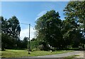
Image Map
Images are licensed for reuse under creativecommons.org/licenses/by-sa/2.0
Notes
- Clicking on the map will re-center to the selected point.
- The higher the marker number, the further away the image location is from the centre of the postcode.
Image Listing (39 Images Found)
Images are licensed for reuse under creativecommons.org/licenses/by-sa/2.0
Image
Details
Distance
2
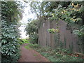
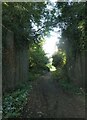
Dismantled bridge on dismantled railway line
The Peddars Way follows this path southward. This line was from Thetford to Watton, opened in 1869 and closed in 1964 under Dr Beeching's proposal
Image: © Martin Dawes
Taken: 15 Sep 2018
0.04 miles
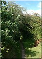
3
Peddars Way south of Stonebridge
The buttress of a dismantled railway bridge can be seen on the right just before the footpath goes right
Image: © Martin Dawes
Taken: 15 Sep 2018
0.05 miles
4
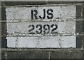
Railway marking on a former bridge
This was found while walking the Peddars Way. It was on the former Crab & Winkle Line approaching Stonebridge: I also found this https://governmentbuildings.co.uk/properties/view/832580
Image: © Basher Eyre
Taken: 25 Sep 2021
0.05 miles
5
Former railway bridge on the Peddars Way
I think it would have been on the Crab & Winkle Line https://en.wikipedia.org/wiki/Bury_and_Thetford_(Swaffham_Branch)
Image: © Basher Eyre
Taken: 25 Sep 2021
0.05 miles
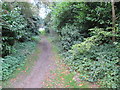
6
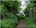
Footpath diversion notice
The faded paper on the almost hidden signpost states that footpath No.3 to Illington was officially diverted in April 2006.
Image: © Bob Jones
Taken: 31 Jul 2007
0.07 miles
7
Former railway along the Peddars Way at Stonebridge
Image: © Mat Fascione
Taken: 28 May 2017
0.07 miles
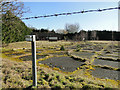
9
Fallen apples on the Peddars Way
They were falling so fast one bonked me on the head!
Image: © Basher Eyre
Taken: 25 Sep 2021
0.08 miles