IMAGES TAKEN NEAR TO
Harefield Road, THETFORD, IP24 1NE
Introduction
This page details the photographs taken nearby to Harefield Road, IP24 1NE by members of the Geograph project.
The Geograph project started in 2005 with the aim of publishing, organising and preserving representative images for every square kilometre of Great Britain, Ireland and the Isle of Man.

There are currently over 7.5m images from over14,400 individuals and you can help contribute to the project by visiting https://www.geograph.org.uk
Image Map
Images are licensed for reuse under creativecommons.org/licenses/by-sa/2.0
Notes
- Clicking on the map will re-center to the selected point.
- The higher the marker number, the further away the image location is from the centre of the postcode.
Image Listing (66 Images Found)
Images are licensed for reuse under creativecommons.org/licenses/by-sa/2.0
Image
Details
Distance
1
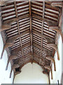
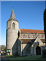
All Saints church - C15 hammerbeam roof
All Saints church > http://www.geograph.org.uk/photo/1697524 is situated about halfway up the hill to the south of the village, beside The Street which is the main thoroughfare. The original structure of the church was built about 1280, and there are indications that it stands on an older site of worship. The round tower is believed to date from Norman times. It has a 14th century octagonal bell stage which is capped by a Victorian spire covered with slates in the Essex style, presumably the only one of this type on a Norfolk church tower. The chancel dates from the early 13th century, the nave was built in the 14th and the clerestory added during the 15th century. The original south aisle was destroyed and later rebuilt in Victorian times > http://www.geograph.org.uk/photo/1697546. Inside the church is a beautiful hammerbeam roof but not much else has survived from medieval times besides the C15 octagonal font > http://www.geograph.org.uk/photo/1697565. The stained glass in the east window > http://www.geograph.org.uk/photo/1697537 was installed in the early 19th century. In 1989 the inner walls were redecorated by unguarded volunteer prisoners from nearby Wayland Prison.
Image: © Evelyn Simak
Taken: 6 Feb 2010
0.05 miles
2
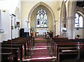
All Saints church - view east
All Saints church > http://www.geograph.org.uk/photo/1697524 is situated about halfway up the hill to the south of the village, beside The Street which is the main thoroughfare. The original structure of the church was built about 1280, and there are indications that it stands on an older site of worship. The round tower is believed to date from Norman times. It has a 14th century octagonal bell stage which is capped by a Victorian spire covered with slates in the Essex style, presumably the only one of this type on a Norfolk church tower. The chancel dates from the early 13th century, the nave was built in the 14th and the clerestory added during the 15th century. The original south aisle was destroyed and later rebuilt in Victorian times > http://www.geograph.org.uk/photo/1697546. Inside the church is a beautiful hammerbeam roof > http://www.geograph.org.uk/photo/1697585 but not much else has survived from medieval times besides the C15 octagonal font > http://www.geograph.org.uk/photo/1697565. The stained glass in the east window > http://www.geograph.org.uk/photo/1697537 was installed in the early 19th century. In 1989 the inner walls were redecorated by unguarded volunteer prisoners from nearby Wayland Prison.
Image: © Evelyn Simak
Taken: 6 Feb 2010
0.05 miles
5
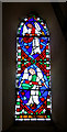
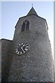
All Saints church - stained glass in tower lancet window
All Saints church > http://www.geograph.org.uk/photo/1697524 is situated about halfway up the hill to the south of the village, beside The Street which is the main thoroughfare. The original structure of the church was built about 1280, and there are indications that it stands on an older site of worship. The round tower is believed to date from Norman times. It has a 14th century octagonal bell stage which is capped by a Victorian spire covered with slates in the Essex style, presumably the only one of this type on a Norfolk church tower. The chancel dates from the early 13th century, the nave was built in the 14th and the clerestory added during the 15th century. The original south aisle was destroyed and later rebuilt in Victorian times > http://www.geograph.org.uk/photo/1697546. Inside the church is a beautiful hammerbeam roof > http://www.geograph.org.uk/photo/1697585 but not much else has survived from medieval times besides the C15 octagonal font > http://www.geograph.org.uk/photo/1697565. The stained glass in the east window > http://www.geograph.org.uk/photo/1697537 was installed in the early 19th century. In 1989 the inner walls were redecorated by unguarded volunteer prisoners from nearby Wayland Prison.
Image: © Evelyn Simak
Taken: 6 Feb 2010
0.05 miles
6
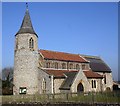
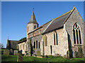
All Saints church
All Saints church > http://www.geograph.org.uk/photo/1697524 is situated about halfway up the hill to the south of the village, beside The Street which is the main thoroughfare. The original structure of the church was built about 1280, and there are indications that it stands on an older site of worship. The round tower is believed to date from Norman times. It has a 14th century octagonal bell stage which is capped by a Victorian spire covered with slates in the Essex style, presumably the only one of this type on a Norfolk church tower. The chancel dates from the early 13th century, the nave was built in the 14th and the clerestory added during the 15th century. The original south aisle was destroyed and later rebuilt in Victorian times > http://www.geograph.org.uk/photo/1697546. Inside the church is a beautiful hammerbeam roof > http://www.geograph.org.uk/photo/1697585 but not much else has survived from medieval times besides the C15 octagonal font > http://www.geograph.org.uk/photo/1697565. The stained glass in the east window > http://www.geograph.org.uk/photo/1697537 was installed in the early 19th century. In 1989 the inner walls were redecorated by unguarded volunteer prisoners from nearby Wayland Prison.
Image: © Evelyn Simak
Taken: 6 Feb 2010
0.05 miles
7
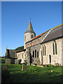
All Saints church - churchyard
For a full view of the church see > http://www.geograph.org.uk/photo/1697524.
Image: © Evelyn Simak
Taken: 6 Feb 2010
0.05 miles
8
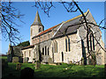
All Saints church viewed from the south-east
All Saints church > http://www.geograph.org.uk/photo/1697524 is situated about halfway up the hill to the south of the village, beside The Street which is the main thoroughfare. The original structure of the church was built about 1280, and there are indications that it stands on an older site of worship. The round tower is believed to date from Norman times. It has a 14th century octagonal bell stage which is capped by a Victorian spire covered with slates in the Essex style, presumably the only one of this type on a Norfolk church tower. The chancel dates from the early 13th century, the nave was built in the 14th and the clerestory added during the 15th century. The original south aisle was destroyed and later rebuilt in Victorian times > http://www.geograph.org.uk/photo/1697546. Inside the church is a beautiful hammerbeam roof > http://www.geograph.org.uk/photo/1697585 but not much else has survived from medieval times besides the C15 octagonal font > http://www.geograph.org.uk/photo/1697565. The stained glass in the east window > http://www.geograph.org.uk/photo/1697537 was installed in the early 19th century. In 1989 the inner walls were redecorated by unguarded volunteer prisoners from nearby Wayland Prison.
Image: © Evelyn Simak
Taken: 6 Feb 2010
0.05 miles
9
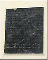
All Saints church - Heere lieth buried
C17 ledger stone on north wall.
All Saints church > http://www.geograph.org.uk/photo/1697524 is situated about halfway up the hill to the south of the village, beside The Street which is the main thoroughfare. The original structure of the church was built about 1280, and there are indications that it stands on an older site of worship. The round tower is believed to date from Norman times. It has a 14th century octagonal bell stage which is capped by a Victorian spire covered with slates in the Essex style, presumably the only one of this type on a Norfolk church tower. The chancel dates from the early 13th century, the nave was built in the 14th and the clerestory added during the 15th century. The original south aisle was destroyed and later rebuilt in Victorian times > http://www.geograph.org.uk/photo/1697546. Inside the church is a beautiful hammerbeam roof > http://www.geograph.org.uk/photo/1697585 but not much else has survived from medieval times besides the C15 octagonal font > http://www.geograph.org.uk/photo/1697565. The stained glass in the east window > http://www.geograph.org.uk/photo/1697537 was installed in the early 19th century. In 1989 the inner walls were redecorated by unguarded volunteer prisoners from nearby Wayland Prison.
Image: © Evelyn Simak
Taken: 6 Feb 2010
0.05 miles
10
All Saints church - path past the Norman tower
All Saints church > http://www.geograph.org.uk/photo/1697524 is situated about halfway up the hill to the south of the village, beside The Street which is the main thoroughfare. The original structure of the church was built about 1280, and there are indications that it stands on an older site of worship. The round tower is believed to date from Norman times. It has a 14th century octagonal bell stage which is capped by a Victorian spire covered with slates in the Essex style, presumably the only one of this type on a Norfolk church tower. The chancel dates from the early 13th century, the nave was built in the 14th and the clerestory added during the 15th century. The original south aisle was destroyed and later rebuilt in Victorian times > http://www.geograph.org.uk/photo/1697546. Inside the church is a beautiful hammerbeam roof > http://www.geograph.org.uk/photo/1697585 but not much else has survived from medieval times besides the C15 octagonal font > http://www.geograph.org.uk/photo/1697565. The stained glass in the east window > http://www.geograph.org.uk/photo/1697537 was installed in the early 19th century. In 1989 the inner walls were redecorated by unguarded volunteer prisoners from nearby Wayland Prison.
Image: © Evelyn Simak
Taken: 6 Feb 2010
0.06 miles