IMAGES TAKEN NEAR TO
High Tree Close, THETFORD, IP24 1LP
Introduction
This page details the photographs taken nearby to High Tree Close, IP24 1LP by members of the Geograph project.
The Geograph project started in 2005 with the aim of publishing, organising and preserving representative images for every square kilometre of Great Britain, Ireland and the Isle of Man.

There are currently over 7.5m images from over14,400 individuals and you can help contribute to the project by visiting https://www.geograph.org.uk
Image Map
Images are licensed for reuse under creativecommons.org/licenses/by-sa/2.0
Notes
- Clicking on the map will re-center to the selected point.
- The higher the marker number, the further away the image location is from the centre of the postcode.
Image Listing (59 Images Found)
Images are licensed for reuse under creativecommons.org/licenses/by-sa/2.0
Image
Details
Distance
2
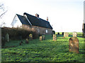
Thatched cottage adjoining All Saints church
The village of Croxton in the Breckland district of Norfolk is situated north of Thetford, covering an area of approximately 19 square kilometres. Croxton has a round-towered parish church dedicated to All Saints > http://www.geograph.org.uk/photo/1697379 and its own general store and Post Office > http://www.geograph.org.uk/photo/1697386.
Image: © Evelyn Simak
Taken: 6 Feb 2010
0.05 miles
3
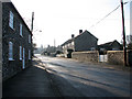
The Street through the village of Croxton
The village of Croxton in the Breckland district of Norfolk is situated north of Thetford, covering an area of approximately 19 square kilometres. Croxton has a round-towered parish church dedicated to All Saints > http://www.geograph.org.uk/photo/1697379 and its own general store and Post Office > http://www.geograph.org.uk/photo/1697386.
Image: © Evelyn Simak
Taken: 6 Feb 2010
0.05 miles
5
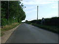
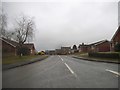
Leaving Croxton
Heading south on The Street.
Image: © JThomas
Taken: 2 Jul 2015
0.06 miles
6
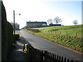
View south from All Saints church
The village of Croxton in the Breckland district of Norfolk is situated north of Thetford, covering an area of approximately 19 square kilometres. Croxton has a round-towered parish church dedicated to All Saints > http://www.geograph.org.uk/photo/1697379 and its own general store and Post Office > http://www.geograph.org.uk/photo/1697386.
Image: © Evelyn Simak
Taken: 6 Feb 2010
0.06 miles
7
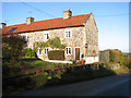
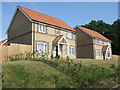
Flint and stone cottage in The Street
The village of Croxton in the Breckland district of Norfolk is situated north of Thetford, covering an area of approximately 19 square kilometres. Croxton has a round-towered parish church dedicated to All Saints > http://www.geograph.org.uk/photo/1697379 and its own general store and Post Office > http://www.geograph.org.uk/photo/1697386.
Image: © Evelyn Simak
Taken: 6 Feb 2010
0.06 miles
8
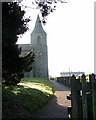
Path to All Saints church
The village of Croxton in the Breckland district of Norfolk is situated north of Thetford, covering an area of approximately 19 square kilometres. Croxton has a round-towered parish church dedicated to All Saints > http://www.geograph.org.uk/photo/1697379 and its own general store and Post Office > http://www.geograph.org.uk/photo/1697386.
Image: © Evelyn Simak
Taken: 6 Feb 2010
0.08 miles
9
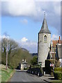
All Saints Church, Croxton
The main structure of the church is believed to have been built around 1280 but there are those of the opinion that the tower dates back to 900-1000 AD.
Image: © Stuart Shepherd
Taken: 5 Mar 2009
0.08 miles
10
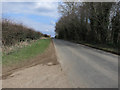
Croxton Road
Minor road to Croxton and STANTA, also part of regional cycle route 30.
Image: © Hugh Venables
Taken: 29 Mar 2013
0.08 miles