IMAGES TAKEN NEAR TO
Croxton, THETFORD, IP24 1LJ
Introduction
This page details the photographs taken nearby to IP24 1LJ by members of the Geograph project.
The Geograph project started in 2005 with the aim of publishing, organising and preserving representative images for every square kilometre of Great Britain, Ireland and the Isle of Man.

There are currently over 7.5m images from over14,400 individuals and you can help contribute to the project by visiting https://www.geograph.org.uk
Image Map
Images are licensed for reuse under creativecommons.org/licenses/by-sa/2.0
Notes
- Clicking on the map will re-center to the selected point.
- The higher the marker number, the further away the image location is from the centre of the postcode.
Image Listing (7 Images Found)
Images are licensed for reuse under creativecommons.org/licenses/by-sa/2.0
Image
Details
Distance
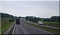
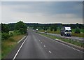
4
The A11 west approaching junction for Croxton
Image: © Roy Hughes
Taken: 14 May 2022
0.21 miles
5
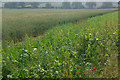
Farmland near Thetford
A field of ripening wheat just to the east of the Croxton road.
Image: © Stephen McKay
Taken: 27 Jun 2010
0.21 miles
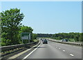
7
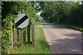
Road to Croxton
The Croxton Road leaves Thetford's built-up area shortly before its junction with the A11, Thetford by-pass.
Image: © Stephen McKay
Taken: 27 Jun 2010
0.23 miles