IMAGES TAKEN NEAR TO
Brunel Way, THETFORD, IP24 1HF
Introduction
This page details the photographs taken nearby to Brunel Way, IP24 1HF by members of the Geograph project.
The Geograph project started in 2005 with the aim of publishing, organising and preserving representative images for every square kilometre of Great Britain, Ireland and the Isle of Man.

There are currently over 7.5m images from over14,400 individuals and you can help contribute to the project by visiting https://www.geograph.org.uk
Image Map
Images are licensed for reuse under creativecommons.org/licenses/by-sa/2.0
Notes
- Clicking on the map will re-center to the selected point.
- The higher the marker number, the further away the image location is from the centre of the postcode.
Image Listing (5 Images Found)
Images are licensed for reuse under creativecommons.org/licenses/by-sa/2.0
Image
Details
Distance
1
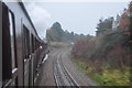
Steaming out of Thetford
The train speeds out of Thetford on the Breckland line. I would imagine this was the last ever steam train to run on this line with the present signalling system.
Image: © Ashley Dace
Taken: 16 Dec 2010
0.09 miles
2
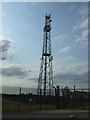
Communications mast off Mundford Road (A1066)
Image: © JThomas
Taken: 2 Jul 2015
0.20 miles
4
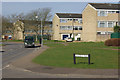
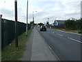
Abbey Farm, Thetford
Looking along Canterbury Way which forms the spine of this Thetford housing estate; all the roads here are named after cathedral cities.
Image: © Stephen McKay
Taken: 15 Mar 2009
0.23 miles