IMAGES TAKEN NEAR TO
Elgin Way, THETFORD, IP24 1EZ
Introduction
This page details the photographs taken nearby to Elgin Way, IP24 1EZ by members of the Geograph project.
The Geograph project started in 2005 with the aim of publishing, organising and preserving representative images for every square kilometre of Great Britain, Ireland and the Isle of Man.

There are currently over 7.5m images from over14,400 individuals and you can help contribute to the project by visiting https://www.geograph.org.uk
Image Map
Images are licensed for reuse under creativecommons.org/licenses/by-sa/2.0
Notes
- Clicking on the map will re-center to the selected point.
- The higher the marker number, the further away the image location is from the centre of the postcode.
Image Listing (13 Images Found)
Images are licensed for reuse under creativecommons.org/licenses/by-sa/2.0
Image
Details
Distance
1
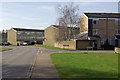
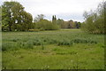
Abbey Farm, Thetford
This is one of several housing estates in Thetford built to absorb London overspill population. Canterbury Way forms the spine of the estate; Edinburgh Way leads off to the right just ahead.
Image: © Stephen McKay
Taken: 15 Mar 2009
0.14 miles
4
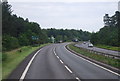
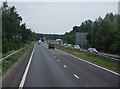
A11 towards London
Here bypassing Thetford.
Image: © Robin Webster
Taken: 7 Apr 2023
0.21 miles
9
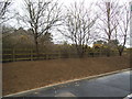
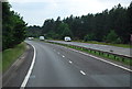
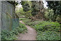
Newly cleared verge by the BP garage on the Thetford bypass
Image: © David Howard
Taken: 27 Mar 2018
0.24 miles
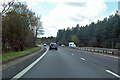
10

BP garage on the Thetford bypass
The fence has been added since 2011
Image: © David Howard
Taken: 27 Mar 2018
0.25 miles