IMAGES TAKEN NEAR TO
Maple Close, EYE, IP23 8DQ
Introduction
This page details the photographs taken nearby to Maple Close, IP23 8DQ by members of the Geograph project.
The Geograph project started in 2005 with the aim of publishing, organising and preserving representative images for every square kilometre of Great Britain, Ireland and the Isle of Man.

There are currently over 7.5m images from over14,400 individuals and you can help contribute to the project by visiting https://www.geograph.org.uk
Image Map
Images are licensed for reuse under creativecommons.org/licenses/by-sa/2.0
Notes
- Clicking on the map will re-center to the selected point.
- The higher the marker number, the further away the image location is from the centre of the postcode.
Image Listing (9 Images Found)
Images are licensed for reuse under creativecommons.org/licenses/by-sa/2.0
Image
Details
Distance
1
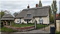
Ivy Dear Cottage, Yaxley
https://historicengland.org.uk/listing/the-list/list-entry/1181753?section=official-list-entry
Image: © Sandy Gerrard
Taken: 3 May 2023
0.07 miles
2
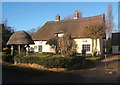
Ivy Cottage, by Mellis Road
A distinctive thatched property with a cute thatched gateway as well.
Image: © Andrew Hill
Taken: 17 Dec 2008
0.09 miles
3
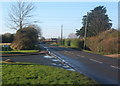
Mellis Road
Heading towards Mellis from Yaxley, passing Burns Close.
Image: © Andrew Hill
Taken: 17 Dec 2008
0.10 miles
5
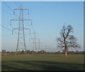
Field with pylons and tree
North of Mellis Road near Yaxley.
Image: © Andrew Hill
Taken: 17 Dec 2008
0.16 miles
6

Mellis Road, heading east from Mellis to Yaxley
Just east of the crossroads with Thornham Road and Judas Lane.
Image: © Christine Johnstone
Taken: 13 Jul 2017
0.18 miles
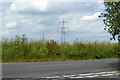
7

Power lines crossing farmland west of Yaxley
Looking north from Mellis Road.
Image: © Christine Johnstone
Taken: 13 Jul 2017
0.21 miles
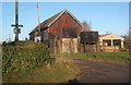
8
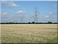
Stubble field and power lines
Off Mellis Road.
Image: © JThomas
Taken: 15 Sep 2015
0.23 miles
9
Power line north of Yaxley
There are also some wind turbines, one is just showing at the right.
Image: © Robin Webster
Taken: 17 Jun 2017
0.23 miles